Approximate Location Map
Large Map »
Latitude: 51.8847 / 51°53'4"N
Longitude: -0.5198 / 0°31'11"W
OS Eastings: 501972
OS Northings: 221713
OS Grid: TL019217
Mapcode National: GBR G50.TMH
Mapcode Global: VHFRC.YW1L
Plus Code: 9C3XVFMJ+V3
Entry Name: Norton House, 52 High Street South
Listing Date: 25 October 1951
Last Amended: 7 February 2023
Grade: II
Source: Historic England
Source ID: 1321399
English Heritage Legacy ID: 35761
ID on this website: 101321399
Location: Dunstable, Central Bedfordshire, LU6
County: Central Bedfordshire
Civil Parish: Dunstable
Built-Up Area: Dunstable
Traditional County: Bedfordshire
Lieutenancy Area (Ceremonial County): Bedfordshire
Church of England Parish: Dunstable
Church of England Diocese: St.Albans
Tagged with: Building
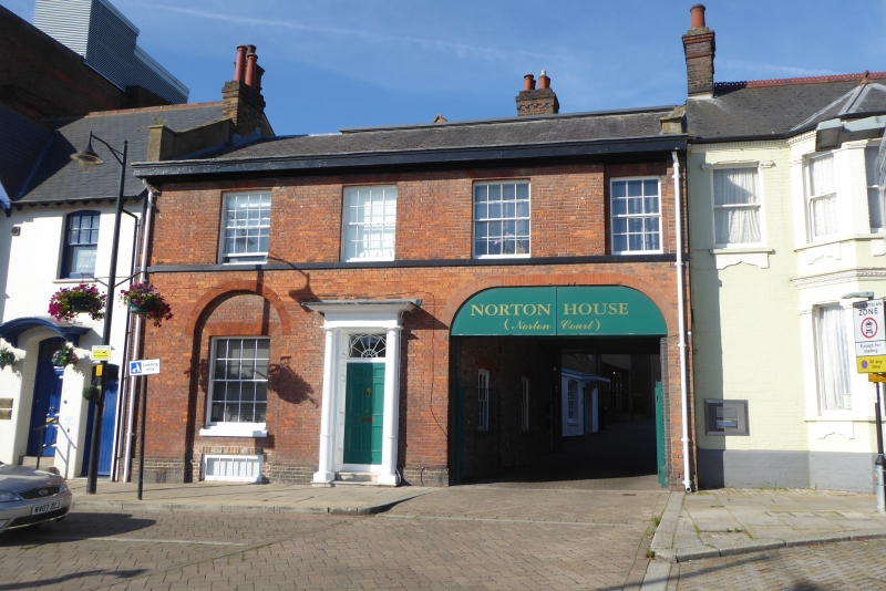
An early C19 building of two storeys with a carriage entrance.
An early C19 building of two storeys with a carriage entrance.
MATERIALS: red brick and Welsh slate.
EXTERIOR: the building has two storeys, beneath a Welsh slate roof with an eaves cornice. The ground floor contains a front entrance doorcase with a fanlight, Roman Doric pilasters and entablature. To the right is an arched carriage entrance, and to the left of the door is one sash window in a semi-circular headed panel. The first floor has three sash windows with flat arches and a fourth recessed, above a storey band.
Dunstable town was historically focused upon the intersection of two ancient routes, the Neolithic Icknield Way, running from east to west, and the Roman Watling Street, running from north to south. The crossroad remains a dominant feature in topography of the town. Dunstable has Roman origins, known as Durocobrivis, centred on the crossroads, which appears to have been abandoned at the end of the Roman period. The town was later re-established in the early C12 by Henry I, centred on the royal lodge of Kingsbury and the Augustinian Priory founded in 1131, dissolved in 1540. A market was established in the wide streets and marketplace, where permanent buildings began to encroach to form Middle Row, possibly from the early C13 onwards. The town continued to prosper as a market town in the post-Medieval period, and also as a significant staging post for coaches travelling along Watling Street. The C19 saw the arrival of the railway, new municipal buildings, and the development of the backland with new terraced housing and small industrial premises, notably hat-making. The C20 saw the growth of the town as an engineering centre. Residential expansion continued apace, with associated provision for schools, churches, and other public buildings.
Norton House was built in the early C19. The OS 25 Inch 1892-1914 map indicates that the building had extensions to the rear and a possible watershed including other ancillary buildings. It was listed in 1976 and was described as follows: "Early C19. Red brick. Welsh slate roof with eaves cornice. 2 storeys. 3 sash windows with flat arches. Right hand ground floor carriageway with elliptical arch. Left hand ground floor window in semi-circular headed panel. Door has good fanlight, Roman Doric pilasters and entablature."
In the late C20 and early C21 it was in use as offices, but in 2018 planning permission was granted to convert it from offices into three flats.
Norton House, 52 High Street South, Dunstable, built in the early C19, is listed at Grade II for the following principal reasons:
Historic and architectural interest:
* as a well-preserved example of a Georgian building;
* for its original features including the doorcase with fanlight, original windows and carriage entrance arch.
External links are from the relevant listing authority and, where applicable, Wikidata. Wikidata IDs may be related buildings as well as this specific building. If you want to add or update a link, you will need to do so by editing the Wikidata entry.


Other nearby listed buildings
