Approximate Location Map
Large Map »
Latitude: 51.4539 / 51°27'14"N
Longitude: -0.9742 / 0°58'27"W
OS Eastings: 471369
OS Northings: 173267
OS Grid: SU713732
Mapcode National: GBR QLG.88
Mapcode Global: VHDWT.2Q99
Plus Code: 9C3XF23G+H8
Entry Name: 35, 36 and 37 St Mary's Butts
Listing Date: 14 December 1978
Last Amended: 7 July 2022
Grade: II
Source: Historic England
Source ID: 1321885
English Heritage Legacy ID: 39152
ID on this website: 101321885
Location: Reading, Berkshire, RG1
County: Reading
Electoral Ward/Division: Abbey
Parish: Non Civil Parish
Built-Up Area: Reading
Traditional County: Berkshire
Lieutenancy Area (Ceremonial County): Berkshire
Church of England Parish: Reading St Mary the Virgin
Church of England Diocese: Oxford
Tagged with: Building
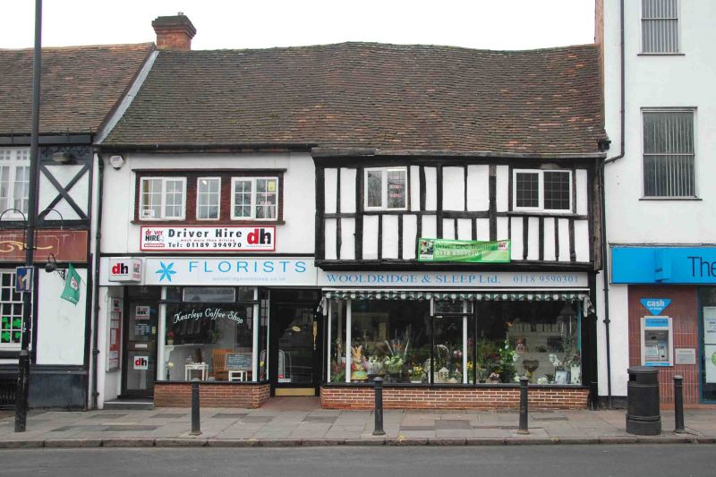
A pair of buildings of C16 or C17 origin, remodelled in the C20.
A pair of buildings of C16 or C17 origin, remodelled in the C20.
MATERIALS: brick and timber frame, C20 brick glazed shop front on a brick plinth and plain tiled roof.
PLAN: the historic plan is obscured on the ground floor, having been opened up into one space to form a single shop unit, but both buildings would have had two rooms to each floor with back to back rear wings. There is a part-attic storey to the wings and a basement under most of the building.
EXTERIOR: two storeys with basement and part-attic. The principal front comprises a later C20 shop front on a brick plinth at the ground floor, with an off-centre late-C20 entrance door to the shop and an additional late-C20 door at the far left, leading to the offices of number 36 above. Number 37 has a bead-moulded jetty bresummer and jetty joists exposed at the soffit. There is no evidence of a jetty plate, presumably it was replaced by the later shopfront but it may be masked by the fascia. Above is close-studded timber framing, with midrails, an exposed wall plate and posts to each end of the jetty. There are two modern, two-light leaded casement windows probably not in the position of the original windows. Number 35 has an entirely late-C20 appearance, with modern shop front and a three-light window in a brick surround to the first floor. The eaves have been cut back slightly, but both 35 and 37 share a gable roof with irregular profile, covered in plain tiles.
To the rear, there are exposed sections of box framing, some rendered or clad with modern materials particularly at number 37. There is a substantial shouldered and truncated brick stack in red brick laid in English bond at the rear of number 35. Between the side elevation of number 35’s rear wing and The Horn Inn to the south is a part-covered passage; the exposed elevations reveal box framing with brick panels laid in stretcher bond, storey posts and a midrail. Some repaired brickwork is apparent, but there are also narrow handmade bricks. There are C20 openings at the rear and side elevations.
INTERIOR: the basement has brick paviours and exposed brick walls for the most part, although some are rendered or overpainted. The front wall is constructed from narrow, handmade, dark red bricks; the bond is irregular but appears to be a variant of English bond. An unusual curved passageway leads to the rear of number 35.
The ground floor has C20 features and finishes with round columns supporting the jetty of number 37. At the rear of number 35’s rear wing is an open fireplace with timber bresummer. It is unclear where the original stairs would have been but a narrow C20 stair leads from the far-left entrance door to the first floor (number 36) where tie beams in the ceiling mark the former cross-walls above number 35; the wall plate to the façade is over painted but evident, but the wall frames are not exposed. The cross-wall between numbers 35 and 37 is partly in situ; a substantial tie beam, wall post and a storey post remain and there are some exposed ceiling joists. The northernmost room has exposed, pegged timber framing of substantial scantling including a jowled storey post and a cranked corner brace at the north-east corner, jointed to a tie beam. Some of the wall framing is of lighter scantling, particularly to the front wall and is probably later in date but the wall plate and bottom of the common rafter roof structure is exposed. The cross wall to the south is similar in form with a substantial tie beam, close studding and straight bracing. This room has two C18 two-panel doors with ‘HL’ hinges. The door leading into the rear of number 35 has part of a moulded architrave remaining with a modern fillet.
The attic had no exposed historic fabric and the upper part of the roof structure was inaccessible.
The first written record of Reading dates from the C9 when the name seems to have referred to a tribe, called Reada’s people. It is possible that there was a river port here during the Roman occupation, and by 1086 there was a thriving urban community, recorded in the Domesday Book. The early Anglo-Saxon settlement is believed to have been located in the Castle Street and St Mary’s area, which has St Mary’s Minster at its heart. A church was established here probably in the late sixth or early seventh century, north of the Holy Brook, important crossings over the river Kennet and the strategic crossroad of important routes from east to west and north to south. The term minster was in use by the C10 denoting a church of importance by the time of Domesday. The Historic Environment Record states that in about 1839 a coffin containing ninth century coins was unearthed by antiquarians in the Minster's churchyard. From the early establishment of a market outside the west door of the minster church, the area has developed over the centuries. Much evidence of this rich history is still apparent in the mix of remaining buildings from different periods, and the likely survival of below ground archaeological remains which may have the potential to inform us about the early history of Reading.
Reading Abbey was founded in 1121, transforming Reading into a place of pilgrimage as well as an important trading and ecclesiastical centre with one of the biggest and richest monasteries in England. The foundation of the Abbey had a direct impact on the St Mary’s area, relocating the focus of economic activity away from the early settlement to a new position east of the town’s historic core probably by the 1400s. The area to the west of St Mary’s was known as ‘olde street’ by about 1160. The strategic position of the crossroads remained however, with the roads leading south to Southampton, east to London, west to Bath and north to the Thames crossing at Caversham. By 1525 Reading was the largest town in Berkshire and the tenth largest in England when measured in taxable wealth, largely due to the wool and cloth trades.
By 1611 the town’s population had grown to over 5,000 as a result of its cloth trade. A number of the timber-framed houses from this period survive in Castle Street and Market Place. At some point between John Speed’s map of 1611 and Man’s early C19 map, Olde Street became St Mary’s Butts, the name it is known by today.
During the C18 Reading became a prosperous market town and administrative centre, due to the development of the town’s waterways and road links. In 1723 the River Kennet was transformed into a canal, linking Reading to Newbury, further extended by the opening of the Kennet and Avon Canal in 1810, to create a route between Reading and the Bristol Channel. Turnpike roads were also improved, establishing major coaching routes from London to Oxford, the West Country and the southern coast. Iron works and brewing caused the expansion of the town further west along the Oxford and Bath Roads and in the older part of Reading, many older, timber-framed buildings were refaced in fashionable brick. A new town hall was built just northeast of the west end of Friary Street in 1786.
In the C19 the town expanded further; three separate railway companies ran routes through the town to London, causing a rapid increase in population (9,400 in 1801 to 21,500 in 1851 and over 70,000 by 1900) as well as the development of Reading’s famous Three B’s industries: beer (Simonds Brewery, 1785–2010), bulbs (Suttons Seeds, 1837–1974) and biscuits (Huntley and Palmers, 1822–1976), although all three have now moved from Reading centre. Growth during this period was characterised by the proliferation of brick terraces. Local clay had been used for tile making from medieval times and then bricks after the C18. In 1869 the town was confirmed as the county town for Berkshire and the extent of the borough was increased to the south in 1887 and again in 1911 to the north and west.
35-37 St Mary's Butts probably have their origins in the late C16 or early C17 (Pevsner, Bradley and Tyack state C16, see sources below), suggested by the jetty form of number 37, and the interior timber frame. They are contemporary, seemingly sharing the same roof structure and box framing characteristics (evident at the rear), but alteration over centuries has obscured their historic relationship. It is likely that 35 and 37 were built as a pair of dwellings with a continuous jetty, and were part of the row of buildings defining the west side of the street, including The Horn Inn to the left (approximately south) (listed at Grade II and believed to have C16 origins). Speed’s map of 1611 indicates buildings on the site, and although the structural details are not clear, they may illustrate the buildings. The Ordnance Survey (OS) 1:2500 map of 1879 indicates an irregular subdivision of the two properties at that time with a covered passageway between number 35 and The Horn. An oblique photograph of 1912 from the Francis Frith Collection suggests a consistent treatment across the frontage of both, notably the jetty and eaves line, weatherboard cladding to the upper floor and the glazed shopfront at the ground floor with mullions; a reeded pilaster to the right-hand side of number 37 is a remnant of a C19 shop front. A photograph of 1968 shows the current (2022) shop front. The façade of number 35 has C20 windows and finishes, with an additional entrance at the left-hand side inserted to access the first-floor office space which is known as number 36. Internally, the ground floor is a single, open retail space with late-C20 finishes; a fireplace opening with a timber bressumer in the rear wing of number 35 was exposed in the late C20.
There is a late-C20 outbuilding in the rear yard.
35, 36 and 37 St Mary’s Butts, Reading is listed at Grade II for the following principal reasons:
Architectural interest:
* as an urban vernacular building of the C16 or C17 that retains a significant proportion of original fabric and important features such as the jetty and well-constructed timber frame.
Historic interest:
* as an early post-medieval vernacular urban building which demonstrates the commercial and domestic occupation of English historic towns at that time.
Group value:
* with the many listed buildings of the C16 and C17 in this particular part of Reading’s historic core, including The Horn Inn and others on Castle Street.
External links are from the relevant listing authority and, where applicable, Wikidata. Wikidata IDs may be related buildings as well as this specific building. If you want to add or update a link, you will need to do so by editing the Wikidata entry.


Other nearby listed buildings
