Approximate Location Map
Large Map »
Latitude: 50.7326 / 50°43'57"N
Longitude: -1.7767 / 1°46'36"W
OS Eastings: 415852
OS Northings: 92582
OS Grid: SZ158925
Mapcode National: GBR 55B.TX8
Mapcode Global: FRA 7754.MN9
Plus Code: 9C2WP6MF+38
Entry Name: 1, CHURCH LANE (See details for further address information)
Listing Date: 12 February 1976
Grade: II
Source: Historic England
Source ID: 1324649
English Heritage Legacy ID: 101475
ID on this website: 101324649
Location: Wick, Bournemouth, Christchurch and Poole, Dorset, BH23
County: Bournemouth, Christchurch and Poole
Parish: Christchurch
Built-Up Area: Christchurch
Traditional County: Hampshire
Lieutenancy Area (Ceremonial County): Dorset
Church of England Parish: Christchurch Holy Trinity
Church of England Diocese: Winchester
Tagged with: Building
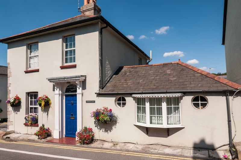
CHURCH IANE
1. (North West Side)
5187
No 1
SZ 1592 1A/133
II GV
2.
Early C19. Corner house. Roughcast facade with hipped slate roof. 2 storeys.
2 windows on each elevation and additional window in 1 storey outshut on Silver
Street. Sashes with glazing bars, cambered heads and jalousies (including some
insertions). Early C19 style doorcsse and 6 panelled door. West side, Church
lane has 1 storey outshut with early C19 style, inserted bow window, flanked
by roundels.
Nos 1 to 12 (consec) (there is no No 5) form a group with Nos 1 and 2 Priory
Place which are buildings of local interest. No 1 also forms part of a group
with buildings on Silver Street.
Listing NGR: SZ1585292582
External links are from the relevant listing authority and, where applicable, Wikidata. Wikidata IDs may be related buildings as well as this specific building. If you want to add or update a link, you will need to do so by editing the Wikidata entry.


Other nearby listed buildings
