Approximate Location Map
Large Map »
Latitude: 50.5114 / 50°30'41"N
Longitude: -4.7303 / 4°43'49"W
OS Eastings: 206512
OS Northings: 71521
OS Grid: SX065715
Mapcode National: GBR N2.K2RT
Mapcode Global: FRA 07ZQ.2XR
Plus Code: 9C2QG769+HV
Entry Name: Helland Bridge
Listing Date: 6 June 1969
Last Amended: 18 November 2021
Grade: I
Source: Historic England
Source ID: 1327910
English Heritage Legacy ID: 67526
ID on this website: 101327910
Location: Cornwall, PL30
County: Cornwall
Civil Parish: Helland
Traditional County: Cornwall
Lieutenancy Area (Ceremonial County): Cornwall
Church of England Parish: St Mabyn
Church of England Diocese: Truro
Tagged with: Road bridge
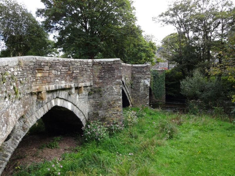
Four-arch bridge, dating from the early-C15, partially rebuilt in the mid-C19, altered in the late-C19. Repaired in the C20 and C21.
Four-arch bridge, dating from the early-C15, partially rebuilt in the mid-C19, altered in the late-C19. Repaired in the C20 and C21.
MATERIALS: slatestone rubble with slate voussoirs and granite copings.
DESCRIPTION: Helland Bridge spans the River Camel north to south with four arches, and is about 40m long and 3m wide. Each arch has a span of approximately 5m, between which are three piers with triangular cutwaters which continue up to road-level to form refuges. The central cutwater projects about 1.5m and the others slightly less. The southern arches are alike and have single rings of slate voussoirs flush with the sides of the bridge. The two arches to the north have two rings of slate voussoirs, the inner slightly recessed from the outer; the second arch from the north was rebuilt with a very pointed arch and there is disturbed masonry in the adjacent piers where replacement voussoirs have been inserted. The arches spring from a level up to 1m above the waterline. At the extreme north-end of the bridge is a smaller early-C19 round-headed arch constructed over the tailrace for the adjacent mill. The river channel is more silted-up beneath these northern arches, and this probably relates to the historic dump-channel from the mill.
The distance between the parapets is almost 3m wide near the centre of the bridge, gradually widening towards each end before splaying out to the width of the modern roadway (approximately 12m). This is particularly evident at the north end above the added early-C19 arch, but the parapet walls were all rebuilt in the late-C18 or early-C19 to accommodate the approach road at each end. The north end of the west parapet wall is supported by a large granite slab on granite corbels; these may be C20 in date and replace a series of bonded-in slabs. The parapet at the far north-east end is topped with C19 wrought-iron railings.
The parapet walls are approximately one-metre high and have chamfered granite coping stones, some with iron cramps, and may have been added following the 1847 flood. Parts of the parapet have been rebuilt following vehicular damage to the bridge. On the roadside of the parapet, at ground level, are some lengths of C20 granite kerbs and a series of granite kick-stones; early examples are rounded. At each end there are C21 traffic-calming measures.
Helland Bridge stands on an early route north out of Bodmin towards the village of St Mabyn and onwards to the coastal hinterland north-east of the Camel estuary. The River Camel marks the boundary of the parishes of St Mabyn to its north and Helland to its south. The bridge is located in a small hamlet with the same name and usually spelled Hellandbridge.
Helland Bridge was first mentioned in the Patent Rolls of 1381, which record that Stephyne Dyer of ‘Helland Brigge’ with others broke down a salmon weir on the Aleyn (Allen) at Dynemore (Dunmere). The bridge itself was first described by John Leland, the King’s Antiquary, in around 1535 as ‘the first memorable bridge on the Alane (Allen) is called Helham Bridge’; Allen is the historic name of the River Camel. In around 1580 John Norden recorded ‘Helenbr.’ on his map of Trigg Hundred, showing the river crossing and houses on the St Mabyn bank. It is named ‘Hellandbridg’ on further maps of 1699 and 1748. It is likely that there was a crossing point in this location prior to it first being recorded.
On the first Ordnance Survey (OS) of 1813, buildings are depicted grouped around the north and south approaches to the bridge. The 1842 Tithe map for St Mabyn shows the bridge in detail and depicts piers with triangular refuges. To the north of the bridge is a mill, and its head and tail races are also shown on the map. It is likely that by this date a further arch had been added to the north end of the bridge to accommodate these. On 16 July 1847, a flash flood swept down the River Camel, damaging Helland Bridge and rising over its parapets, but not causing the total destruction it wrought on most other bridges along the valley. The strongly-pointed arch north of centre and the adjacent cutwater were reconstructed following the incident. The 1881 OS map shows the mill, then for corn, along with its water system. A dump channel from the headrace passes under the bridge’s northern arch, cutting across what appears to be an earlier and abandoned channel further east along the headrace. It is likely that the two northern arches of the bridge were designed to span this earlier channel and may have been lengthened in response to the mill’s requirements, possibly replacing a causeway and floodwater-arch over the floodplain. The 1907 OS map shows that little had changed by the early years of the C20.
In the 1920s Helland Bridge was visited by the historian Charles Henderson and Henry Coates, a photographer. Henderson noted that the bridge was probably early C15 (by a comparison of styles) and was in perfect condition, although one arch had been rebuilt. He proclaimed it as ‘one of the finest old bridges in the west’.
The road across Helland Bridge lost its importance in the post-medieval period, with the preferred crossing point on the River Camel being downstream at Dunmere Bridge. Helland Bridge therefore became a secondary route.
Helland Bridge, near Bodmin, dating from the early-C15 with C19 alteration and rebuilding and later repairs, is listed at Grade I for the following principal reasons:
Architectural interest:
* as a well-documented early-C15 bridge which, although the parapets have been repaired and rebuilt, retains a good proportion of its early fabric;
* the principal structure is well-constructed using local materials including granite and slatestone, and the different phases of construction are evident.
Historic interest:
* it forms part of a historic route north from Bodmin to the coastal hinterland of the Camel estuary;
* repair and alterations in the C19 can be related to specific factors and contribute to its special interest.
External links are from the relevant listing authority and, where applicable, Wikidata. Wikidata IDs may be related buildings as well as this specific building. If you want to add or update a link, you will need to do so by editing the Wikidata entry.


Other nearby listed buildings
