Approximate Location Map
Large Map »
Latitude: 50.6149 / 50°36'53"N
Longitude: -2.4523 / 2°27'8"W
OS Eastings: 368092
OS Northings: 79564
OS Grid: SY680795
Mapcode National: GBR PY.D3TX
Mapcode Global: FRA 57RF.VVM
Plus Code: 9C2VJG7X+X3
Entry Name: Promenade Shelter Approximately 55 Metres North of the Jubilee Clock Tower
Listing Date: 22 December 1997
Grade: II
Source: Historic England
Source ID: 1328299
English Heritage Legacy ID: 467622
ID on this website: 101328299
Location: Melcombe Regis, Dorset, DT4
County: Dorset
Electoral Ward/Division: Melcombe Regis
Parish: Non Civil Parish
Built-Up Area: Weymouth
Traditional County: Dorset
Lieutenancy Area (Ceremonial County): Dorset
Church of England Parish: Radipole and Melcombe Regis
Church of England Diocese: Salisbury
Tagged with: Clock tower
WEYMOUTH
SO6879NW ESPLANADE
873-1/18/168 (East side)
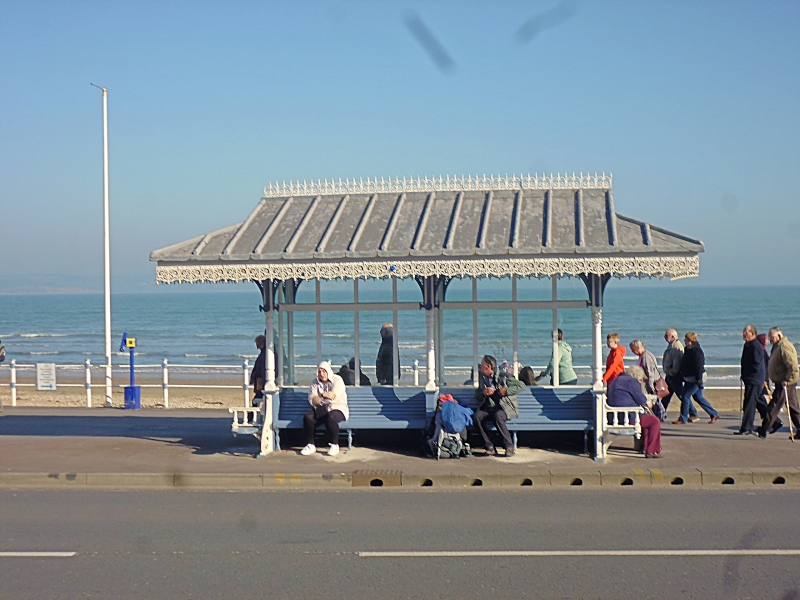
Promenade shelter approx 55 metres
north of Jubilee Clock Tower
GV II
Promenade shelter. Late C19. Cast-iron and wood structure with
timber glazed panels, lead covered wood roof.
The low-pitched hipped roof has small gablets, and rich
fretted decorative cast-iron embellishment to the ridge and to
the eaves on all sides, covering an open-sided 2-bay shelter
on 3 pairs of slender turned wood columns with cast-iron
fretted brackets to a grid of moulded beams and a panelled
soffit in 12 compartments, plus diagonal 'dragon beams' to the
corner bays. Glazed screens have a central mullion, and a
transom at the bracket springing height; wooden slatted seats
are set to cast-iron brackets, but the seat to the N has been
removed.
One of 7 similar shelters (qv), maintained in good condition,
this one is set back from the promenade edge, but formerly
would have been at the edge, with its own railed balcony; the
promenade has been widened here. All detail appears to be
original; no founder's or contractor's plate survives.
Listing NGR: SY6809279564
External links are from the relevant listing authority and, where applicable, Wikidata. Wikidata IDs may be related buildings as well as this specific building. If you want to add or update a link, you will need to do so by editing the Wikidata entry.


Other nearby listed buildings
