Approximate Location Map
Large Map »
Latitude: 54.5024 / 54°30'8"N
Longitude: -0.9992 / 0°59'56"W
OS Eastings: 464910
OS Northings: 512356
OS Grid: NZ649123
Mapcode National: GBR PJGC.HS
Mapcode Global: WHF8M.M3F7
Plus Code: 9C6XG222+X8
Entry Name: Pair of Boundary Stones, Circa 1, 870 Metres South of Tidkinhow Farmhouse
Listing Date: 8 September 1986
Grade: II
Source: Historic England
Source ID: 1329587
English Heritage Legacy ID: 60141
ID on this website: 101329587
Location: North Yorkshire, YO21
County: North Yorkshire
District: Scarborough
Civil Parish: Commondale
Traditional County: Yorkshire
Lieutenancy Area (Ceremonial County): North Yorkshire
Church of England Parish: Danby with Castleton and Commondale
Church of England Diocese: York
Tagged with: Boundary marker
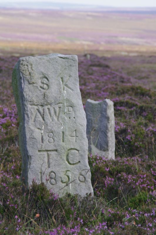
NZ 61 SW (NZ 649 123) LOCKWOOD STANGHOW MOOR, Stanghow
5/94 Pair of boundary stones,
c.1,870m south of
Tidkinhow Farmhouse
II
2 boundary stones, early C19. Roughly-dressed limestone shafts. One to
west approximately 37cm x 25cm x one metre high. West face inscribed 'S.K.
A.W.D
1814
T.C.
1856
G'
Second stone, to east, approximately 30cm square by 67cm high. Without
inscription or marks. Both stand at junction of boundaries of Guisborough,
Commondale and former Stanghow parishes and on the boundary between the
counties of Cleveland and North Yorkshire.
Listing NGR: NZ6491012356
External links are from the relevant listing authority and, where applicable, Wikidata. Wikidata IDs may be related buildings as well as this specific building. If you want to add or update a link, you will need to do so by editing the Wikidata entry.


Other nearby listed buildings
