Approximate Location Map
Large Map »
Latitude: 50.6833 / 50°40'59"N
Longitude: -3.4656 / 3°27'56"W
OS Eastings: 296552
OS Northings: 88094
OS Grid: SX965880
Mapcode National: GBR P2.JRKM
Mapcode Global: FRA 37M8.HNP
Plus Code: 9C2RMGMM+8P
Entry Name: 65, Fore Street
Listing Date: 18 June 1974
Grade: II
Source: Historic England
Source ID: 1333414
English Heritage Legacy ID: 89161
ID on this website: 101333414
Location: Topsham, Exeter, Devon, EX3
County: Devon
District: Exeter
Electoral Ward/Division: Topsham
Parish: Non Civil Parish
Built-Up Area: Topsham
Traditional County: Devon
Lieutenancy Area (Ceremonial County): Devon
Church of England Parish: Topsham St Margaret
Church of England Diocese: Exeter
Tagged with: Building
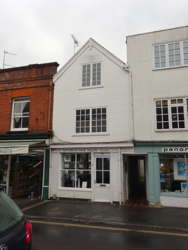
FORE STREET
1.
1092
(West Side)
TOPSHAM
No 65
SX 9687 8/902
II GV
2.
C17/C18. Timber framed and rendered. Gable end to street. C19 shop front. Two
storeys and attic, one small-paned window on the first floor, modern casement above.
All the listed buildings in Fore Street form a group.
Listing NGR: SX9655288094
External links are from the relevant listing authority and, where applicable, Wikidata. Wikidata IDs may be related buildings as well as this specific building. If you want to add or update a link, you will need to do so by editing the Wikidata entry.


Other nearby listed buildings
