Approximate Location Map
Large Map »
Latitude: 51.2774 / 51°16'38"N
Longitude: 1.0871 / 1°5'13"E
OS Eastings: 615405
OS Northings: 157666
OS Grid: TR154576
Mapcode National: GBR TY2.ZLH
Mapcode Global: VHLGM.S5K2
Plus Code: 9F3373GP+XR
Entry Name: 13 and 14, Longport
Listing Date: 7 September 1973
Grade: II
Source: Historic England
Source ID: 1334300
English Heritage Legacy ID: 439686
ID on this website: 101334300
Location: St Martin's, Canterbury, Kent, CT1
County: Kent
District: Canterbury
Electoral Ward/Division: Barton
Parish: Non Civil Parish
Built-Up Area: Canterbury
Traditional County: Kent
Lieutenancy Area (Ceremonial County): Kent
Tagged with: Building
1.
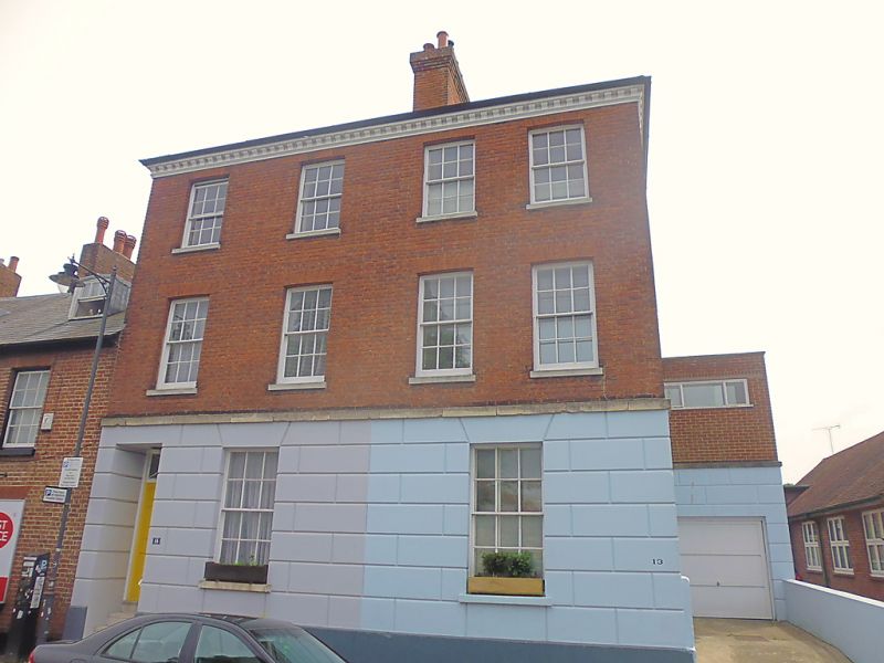
944 LONG PORT
(South Side)
Nos 13 & 14
TR 1557 NW 5/548
II GV
2.
Mid C19. 3 storeys red brick. Ground floor stuccoed. Hipped slate roof with
bracket cornice. 4 sashes with glazing bars intact. Simple doorcase with
rectangular fanlight and panelled door. 5 stone steps.
Nos 13 to 17 (consec) form a group.
Listing NGR: TR1540157661
External links are from the relevant listing authority and, where applicable, Wikidata. Wikidata IDs may be related buildings as well as this specific building. If you want to add or update a link, you will need to do so by editing the Wikidata entry.


Other nearby listed buildings
