Approximate Location Map
Large Map »
Latitude: 51.2814 / 51°16'53"N
Longitude: 1.0798 / 1°4'47"E
OS Eastings: 614877
OS Northings: 158092
OS Grid: TR148580
Mapcode National: GBR TY2.PS7
Mapcode Global: VHLGM.N1PZ
Plus Code: 9F3373JH+HW
Entry Name: Wall on Right Side of Blackfriars Monastery
Listing Date: 7 September 1973
Grade: II
Source: Historic England
Source ID: 1336779
English Heritage Legacy ID: 170392
ID on this website: 101336779
Location: Canterbury, Kent, CT1
County: Kent
District: Canterbury
Electoral Ward/Division: Westgate
Parish: Non Civil Parish
Built-Up Area: Canterbury
Traditional County: Kent
Lieutenancy Area (Ceremonial County): Kent
Tagged with: Wall
1.
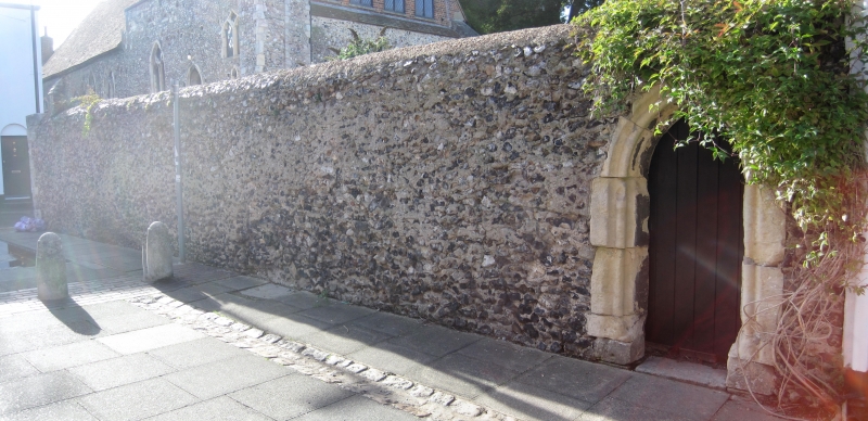
944 BLACKFRIARS STREET
(West Side)
Wall on right side
of Blackfriars Monastery
TR 1458 SE 2/91A
II GV
2.
A Mediaeval flint wall about 10 foot high, which was once part of the monastery.
Stone moulded and pointed arch with stone quoins.
Forms a group with the former Blackfriars Monastery.
Listing NGR: TR1487758092
External links are from the relevant listing authority and, where applicable, Wikidata. Wikidata IDs may be related buildings as well as this specific building. If you want to add or update a link, you will need to do so by editing the Wikidata entry.


Other nearby listed buildings
