Approximate Location Map
Large Map »
Latitude: 51.2762 / 51°16'34"N
Longitude: 1.076 / 1°4'33"E
OS Eastings: 614635
OS Northings: 157502
OS Grid: TR146575
Mapcode National: GBR TY2.WC5
Mapcode Global: VHLGM.L5PZ
Plus Code: 9F3373GG+F9
Entry Name: 25, Castle Street
Listing Date: 7 September 1973
Grade: II
Source: Historic England
Source ID: 1336799
English Heritage Legacy ID: 170501
ID on this website: 101336799
Location: Canterbury, Kent, CT1
County: Kent
District: Canterbury
Electoral Ward/Division: Westgate
Parish: Non Civil Parish
Built-Up Area: Canterbury
Traditional County: Kent
Lieutenancy Area (Ceremonial County): Kent
Tagged with: Building
1.
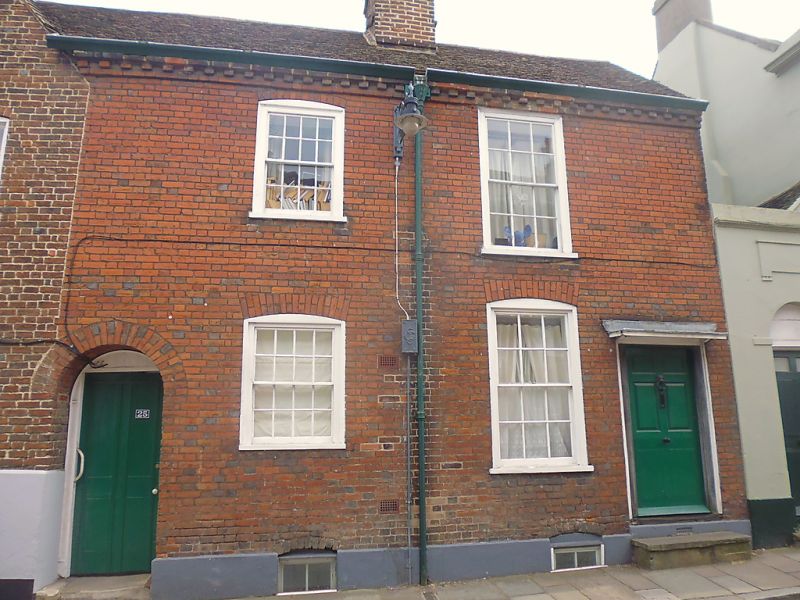
944 CASTLE STREET
(South East Side)
TR 1457 NE 4/260 No 25
TR l457 SE 8/260
II GV
2.
Early C18. 2 storeys red brick. Old tiled roof. Rainwater head. Brick
modillion cornice. 2 sashes with glazing bars intact most cambered. Plinth.
Doorcase has wooden hood with console brackets and 6 fielded panels.
Nos 25 and 26 together with Nos 37 to 41 (consec) Castle Row form a group.
Listing NGR: TR1463357501
External links are from the relevant listing authority and, where applicable, Wikidata. Wikidata IDs may be related buildings as well as this specific building. If you want to add or update a link, you will need to do so by editing the Wikidata entry.


Other nearby listed buildings
