Approximate Location Map
Large Map »
Latitude: 52.4596 / 52°27'34"N
Longitude: -1.9462 / 1°56'46"W
OS Eastings: 403750
OS Northings: 284629
OS Grid: SP037846
Mapcode National: GBR 5PJ.45
Mapcode Global: VH9Z2.6FZT
Plus Code: 9C4WF353+RG
Entry Name: The Clock Tower Community Education Centre
Listing Date: 8 July 1982
Grade: II
Source: Historic England
Source ID: 1343074
English Heritage Legacy ID: 217294
ID on this website: 101343074
Location: Birmingham, West Midlands, B17
County: Birmingham
Parish: Non Civil Parish
Built-Up Area: Birmingham
Traditional County: Staffordshire
Lieutenancy Area (Ceremonial County): West Midlands
Church of England Parish: Harborne St John
Church of England Diocese: Birmingham
Tagged with: Clock tower
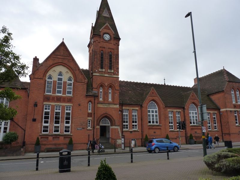
HIGH STREET
1.
5104
Harborne B17
The Clock Tower
Community Education
Centre and No 106
SP 08 SW 11/25
II
2.
Circa 1885 by Martin and Chamberlain, and built as a school. Red brick and
terracotta with minimum stone dressings; tile roof with decorative ridge tiles.
Asymmetrical composition partly of one and partly of 2 storeys; 6 bays, with a
tower in the third. Bay one is No 106 the former master's house with ground floor
canted bay window and tripartite first floor window beneath a half-hipped roof.
Set back on the left of this, the gabled entrance bay with pointed-arched door. Bay
2 is broad, gabled and 2 storeys high, its ground and first floor windows separated
from one another by a band of decorative brickwork and set within a shallow pointed
arched recess. The clock tower with the principal entrance to the school, 2 tiers
of lancet openings and clock faces beneath gablets rising into the spire zone; spire
with lucarnes and a fanciful finial. The fourth and fifth bays each with broad pointed
casement windows within gables projecting into the roof. The sixth bay is 2-storeyed
with a half-hipped roof and mostly pointed windows, some narrow and some broader.
Listing NGR: SP0375084629
External links are from the relevant listing authority and, where applicable, Wikidata. Wikidata IDs may be related buildings as well as this specific building. If you want to add or update a link, you will need to do so by editing the Wikidata entry.


Other nearby listed buildings
