Approximate Location Map
Large Map »
Latitude: 52.4119 / 52°24'42"N
Longitude: -1.9735 / 1°58'24"W
OS Eastings: 401896
OS Northings: 279326
OS Grid: SP018793
Mapcode National: GBR 2F2.RWC
Mapcode Global: VH9Z7.RM1W
Plus Code: 9C4WC26G+QH
Entry Name: The Black Horse public house
Listing Date: 19 March 1981
Last Amended: 24 August 2015
Grade: II*
Source: Historic England
Source ID: 1343340
English Heritage Legacy ID: 216818
ID on this website: 101343340
Location: Northfield, Birmingham, West Midlands, B31
County: Birmingham
Parish: Non Civil Parish
Built-Up Area: Birmingham
Traditional County: Worcestershire
Lieutenancy Area (Ceremonial County): West Midlands
Church of England Parish: Allens Cross St Bartholomew
Church of England Diocese: Birmingham
Tagged with: Pub Tudor Revival architecture
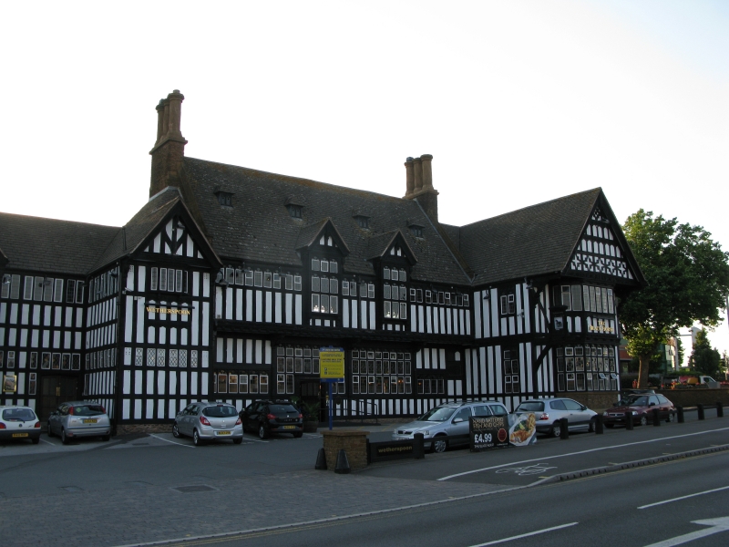
A public house, designed by Francis Goldsbrough (of Bateman and Bateman) for the brewers John Davenport & Sons and built in 1929-30 in a late-medieval and Tudor style, designed to represent gradual growth.
A public house, designed by Francis Goldsbrough (of Bateman and Bateman) for the brewers John Davenport & Sons and built in 1929-30 in a late-medieval and Tudor style, designed to represent gradual growth.
MATERIALS: timber framed with white-washed infill and Cotswold stone with ashlar dressings, with a roof of stone and clay tiles. Many of the timbers, such as bressumers, wall plates and barge boards, are richly carved. Stone brackets are also carved and metal rain water heads an guttering have cast decoration.
PLAN: the building runs north to south, with a lengthy road front which faces east and a garden front to the west. The landlord’s house is set at the south end of the range and the pub building has a public bar to the centre with three further bar areas housed in projecting wings. These were originally a combined Dining and Assembly Room projecting at the southern end of the west front, and a Gentlemen’s Smoking Room at the northern end of this western front. The eastern front had a Mixed Smoking Room projecting at its northern end and there was an ‘Outdoor Department’ (off-sales) immediately to the south of this. The off-sales area has now been removed and the bar rooms are joined by wide doorways to form a series of interconnected bar areas for eating or drinking. However, the various rooms retain their original, individual characters. A colonnade along the western side, which overlooks the garden, and originally incorporated a garden service area, has now been glazed and incorporated as an extension to the public bar area. To either end of the ground floor are entrance halls, off which are lavatories. At first-floor level there is a large Club Room at the centre, with a Committee Room above the former Mixed Smoking Room in the wing to the east.
EXTERIOR: the EASTERN, ROAD FRONT has a projecting portion to the centre, with a higher ridge than the recessed wings to either side. This is timber framed and has close-studded walling rising from a stone plinth, which is common to the whole of the building. The central portion is divided into four bays by moulded posts. The two central, ground-floor bays each have glazing to their full width with 8x3 lights, divided by mullions and transoms. The principal entrance door is set at the middle of the left of these two bays and has a moulded surround and four-centred head. The far left of these four bays has a horizontal window of six lights and the corresponding right hand bay has one of four lights and the blocked doorway of the former off-sales department. The first floor has a deep jetty which is supported by carved figurehead brackets and the bressumer is richly moulded. The first floor of this portion has a continuous horizontal window below the eaves. Overlaying this, but incorporating the row of horizontal lights, are two, central, oriel windows with moulded surrounds and gabled heads. The steep roof slope above has four dormer windows, each with two casement lights and a hipped roof. To either side of the central, prominent roof are raised, cross axial gables, whose coping stones project above the roof line, and attached to them are prominent cross-axial stacks with moulded chimney flues.
Projecting at right of this is a prominent gabled wing with close-studded walling and richly-carved timbers. Its eastern, gabled end has a canted, two-storey bay window. To either side of this at first-floor level are deep brackets carved in the form of horses which rise to support the deeply-jettied gable end. The gable end has cells of decorative timber framing. The flanks of the wing have two and four-light windows with carved heads to the lights. Recessed, and at right of this wing, is a further range with stone walling to the ground floor and close studding to the first floor. This has a doorway with moulded stone surround and Tudor arch and a staircase window extending through the full height of the first floor.
To left of centre are two projecting gabled wings with close studding, as before. Each has an oriel at first floor level which supports a jettied gable with decorative framing. The manager's house at far left has stone walling to the ground floor and timber framing above, with a door at right of centre and a combination of three-light casements and random fenestration.
The SOUTH FLANK has a projecting stack at right of centre with ashlar and tiled offsets. To the right of this the ground floor is stone walled with a two-light casement. Above this the first floor has timber framing and a three light casement. At left of the stack the walling to both floors is stone, with five-light mullioned windows to each floor and a tile hung gable.
The NORTH FLANK of the building has a gabled wing with first-floor oriel and jettied gable, with decorative framing and carved bressumer. At ground-floor level is a later-C20 projecting, flat-roofed store with stone walling.
The WESTERN, GARDEN FRONT has a combination of stone and timber-framed vernacular architecture. At far left is the timber-framed north end of the spinal range. Projecting at left of centre is the single-storey, former Gentlemen’s Smoking Room, which has stone walling to the ground floor of its west front, and a canted bay beneath the jettied, timber-framed gable. Its northern and southern flank walls are timber framed, with a projecting chimney breast to the north side. At the centre of the front the first-floor windows repeat the continuous horizontal band seen on the road front. Below these the roof slope continues as a clay-tiled catslide over the colonnade, which was formerly open to the garden and then glazed in the late C20. This has circular pillars of Cotswold rubble with ashlar caps and concrete lintels. There are three small attic dormers and a later, gabled ventilation grille to the attic. The left-hand bay of the colonnade has been blocked and above it is a projecting, gabled wing with small-framed walls. The dining room wing projects to the right of this and has stone walling and a flat roof. At the centre of its west front is a canted bay and to the flanks are mullioned and transomed windows. To right of this is a three-storey tower with prominent chimney stack and a gabled wing, both of stone and to the far right is the rear of the manager’s house which has two, joined, timber-framed gables at first-floor level with stone walling to the ground floor.
INTERIOR: the Public Bar has small-framed walling and a beamed ceiling. The southern end of the room gives the impression of a large inglenook, with a lower ceiling and a fireplace with stone surround which includes a carved roundel showing a rearing, black horse. A glazed porch and new bar counter and bar back in blond oak were inserted in the early C21 in the original position against the west wall. The northern wall has an inserted wide entrance leading to the former off-sales area, with which the public bar is now combined.
The former Mixed Smoking Room has oak panelling to the lower walls, above which are panels of small framing with cusped heads. A fireplace in the south wall has a carved, stone surround which has been painted. The beamed ceiling has been lowered at the sides to accommodate ventilation ducts.
The former Gentlemen’s Smoking Room has timber-framed walls and a carved stone, Tudor fire surround to the north side. The roof is panelled to its upper part, but the lower body of the roof trusses can be seen, and these have a series of vertical struts. Fixed benches have been removed from the sides of the room, below the moulded dado, and a bar, which is a free-standing extension of the service area, has been added at the south-eastern corner of the room.
The Dining or Assembly Room has wood panelling to its lower walls, with arched tops to the panels. The moulded and panelled ceiling has been adapted to incorporate ventilation ducting, so that alternating rows of panels are either at their original height, or else suspended.
The Southern Entrance Lobby has panelled walls and a barrel-vaulted plaster ceiling with rectangular panels which have moulded borders of foliage. At the top of the wall is a fluted frieze with small rectangular panels in relief showing medieval figures drinking. Doors lead to the kitchen and to the dining room and an archway, flanked by Ionic columns, gives access to a staircase to the first floor.
The first-floor anteroom, off the staircase landing, is similar to the entrance hall below, with a barrel-vaulted plaster ceiling with rectangular panels, bordered by a continuous vine trail. Rectangular plaster bosses are placed at the intersections of the panels and show characters in period dress.
The Club Room takes up much of the central first-floor area. It is lit by continuous horizontal windows to its east and west sides, which have cusped heads to the individual lights. Aisle posts stand proud of the wall to support encased ties, moulded crown posts and heavy, arched braces. Wooden brackets at the tops of the posts were carved by Jean Hahn with figures, apparently representing different races. At the south end is a stone fire surround with richly moulded support below the mantel shelf, which was carved by Sidney Smithin. Above this a diminishing, exposed flue has a bracket to its centre which supports a bronze bust of Baron John Davenport, chairman of the brewery.
The Committee Room is approximately square and in early-C18 style. It has painted bolection panelling to the walls and a plaster ceiling with a deeply-moulded circular wreath, which surrounds a shallow, central dome. A northern, dogleg staircase leads down to the entrance lobby at this end of the building.
The former Manager’s House has an entrance hall which is divided from its staircase by an open screen of moulded balusters. The ground-floor living room has been subdivided.
Pursuant to s1 (5) of the Planning (Listed Buildings and Conservation Areas) Act 1990 it is declared that the single-storey, flat-roofed store to the north of the Black Horse, which was built after 1936, is not of special architectural or historic interest.
Inter-war ‘improved’ or ‘reformed’ pubs stemmed from a desire to cut back on the amount of drunkenness associated with conventional Victorian and Edwardian public houses. Licensing magistrates and breweries combined to improve the facilities and reputation of the building type. Improved pubs were generally more spacious than their predecessors, often with restaurant facilities, function rooms and gardens, and consciously appealed to families and to a mix of incomes and classes. Central, island serveries with counters opening onto several bar areas allowed the monitoring of customers and also the efficient distribution of staff to whichever area needed service. Many, although not all, of the new pubs were built as an accompaniment to new suburban development around cities, and a policy of ‘fewer and better’ was followed by magistrates both in town and on the outskirts. A licence might be granted for a new establishment on surrender of one or more licences for smaller urban premises. Approximately 1,000 new pubs were built in the 1920s – the vast majority of them on ‘improved’ lines - and almost 2,000 in the period 1935-39. Neo-Tudor and Neo-Georgian were the favoured styles, although others began to appear at the end of the period.
The Black Horse was designed by Francis Goldsbrough (of Bateman and Bateman) for the brewers John Davenport & Sons. The brewery dated back to the early C19 and had great success in the early C20 with their home deliveries of beer, called ‘Beer at Home’, allied to a string of public houses. The previous pub on the site was demolished and the present Black Horse opened in 1929. Stone carving is by Sidney Smithin and wood carving by Jean Hahn. At some date in the later C20 the off-sales lobby and counter were incorporated into the public bar area, and the colonnade overlooking the garden was glazed and firstly changed to a kitchen area in the 1980s and then to a seating area, forming an extension of the public bar. In the later C20 and early C21 alterations were made, including the insertion of a glazed lobby entrance to the public bar, the rebuilding of the bar and bar back in the public bar, the insertion of a bar counter in the former Gentlemen’s Smoking Room, and the partial lowering of the ceiling in the Mixed Smoking Room and the Dining Room. Parts of the northern entrance hall were also converted to form additional lavatory space. The manager’s house has now been subdivided, but still functions as staff housing and an external, spiral fire escape has been added on the west side.
Davenport’s Brewery was taken over by Greenall Whitley in 1986 and the pub is now (2015) a Wetherspoon’s house. Alterations and restorations date from the 1980s and 2011.
The Black Horse Public House, Northfield, Birmingham is listed at Grade II* for the following principal reasons:
* Architectural quality: the building is widely considered to be one of the finest examples of public house architecture of the inter-war period, combining careful planning, authentic construction, imaginative design and inspired craftsmanship;
* Intact survival: although there has been some alteration, notably in the inter-connection of the bar spaces at ground floor level and the insertion of air conditioning, this has been done sympathetically and the individual bar and assembly rooms retain their power as architectural spaces and much of their original detailing;
* Historic interest: the Black Horse was designed as the flagship public house of Davenport's Brewery by the noted architect Francis Goldsborough of Bateman & Bateman. It is a very good example of an 'improved' public house as these buildings developed in the Birmingham region.
External links are from the relevant listing authority and, where applicable, Wikidata. Wikidata IDs may be related buildings as well as this specific building. If you want to add or update a link, you will need to do so by editing the Wikidata entry.


Other nearby listed buildings
