Approximate Location Map
Large Map »
Latitude: 51.2875 / 51°17'15"N
Longitude: 0.4394 / 0°26'21"E
OS Eastings: 570198
OS Northings: 157089
OS Grid: TQ701570
Mapcode National: GBR NPL.9WK
Mapcode Global: VHJM5.KWMW
Plus Code: 9F327CQQ+2P
Entry Name: 4 and 6, Church Walk
Listing Date: 1 August 1952
Last Amended: 25 February 1987
Grade: II*
Source: Historic England
Source ID: 1349080
English Heritage Legacy ID: 179316
ID on this website: 101349080
Location: East Malling, Tonbridge and Malling, Kent, ME19
County: Kent
District: Tonbridge and Malling
Town: Tonbridge and Malling
Civil Parish: East Malling and Larkfield
Built-Up Area: Ditton
Traditional County: Kent
Lieutenancy Area (Ceremonial County): Kent
Church of England Parish: East Malling St James
Church of England Diocese: Rochester
Tagged with: Building
EAST MALLING & LARKFIELD CHURCH WALK
TQ 75 NW
(south side)
8/142
Nos 4 & 6 (formerly listed
1.8.52 as cottages occupied by
H Coley and W Hudson)
GV II*
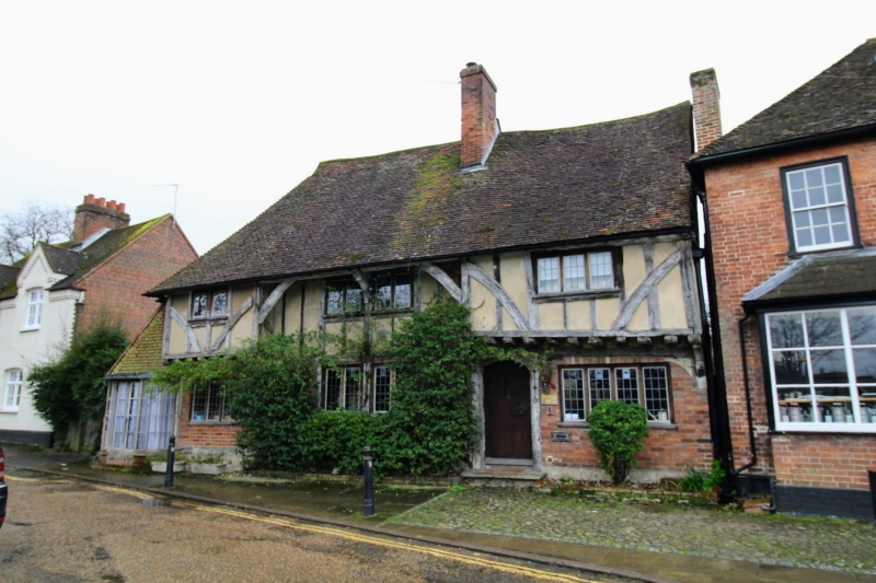
House, formerly hall-house of classic Wealden type. Early C15. Timber-framed
with red brick infilling on ground floor and plaster infilling on first floor.
Jetties on first floor in left and right hand bays and angle pieces supporting
eaves in centre. Steep plain tiled roof, hipped with gablet to left and brought
down as catslide extension. Large brick ridge stack to right of centre. 2
storeys; 3 window front, slightly irregular, wooden mullion casements. Boarded
door in 4-centred arched surround under left end of right-hand jetty. INTERIOR:
Drawing room. Moulded wooden bressumer to fireplace. Moulded central beam to
insulated ceiling. Same original mouldings survive in drawing room from hall,
including embattled dais-beam. Kitchen. Spere-truss survives in situ. Moulded
octagonal crown-post to collar-purlin roof.
Listing NGR: TQ7019657088
External links are from the relevant listing authority and, where applicable, Wikidata. Wikidata IDs may be related buildings as well as this specific building. If you want to add or update a link, you will need to do so by editing the Wikidata entry.


Other nearby listed buildings
