Approximate Location Map
Large Map »
Latitude: 52.1412 / 52°8'28"N
Longitude: -2.2172 / 2°13'1"W
OS Eastings: 385235
OS Northings: 249237
OS Grid: SO852492
Mapcode National: GBR 1GQ.Q8H
Mapcode Global: VH930.JF7W
Plus Code: 9C4V4QRM+F4
Entry Name: 68, Main Road
Listing Date: 25 March 1968
Grade: II
Source: Historic England
Source ID: 1349243
English Heritage Legacy ID: 153346
ID on this website: 101349243
Location: Kempsey, Malvern Hills, Worcestershire, WR5
County: Worcestershire
District: Malvern Hills
Civil Parish: Kempsey
Built-Up Area: Kempsey
Traditional County: Worcestershire
Lieutenancy Area (Ceremonial County): Worcestershire
Church of England Parish: The baptist
Church of England Diocese: Worcester
Tagged with: House
This list entry was subject to a Minor Amendment on 09/09/2020
SO 8449-8549
9/33
KEMPSEY CP
MAIN ROAD (east side)
No 68
(Formerly listed as No 68 (Melbury House), WORCESTER ROAD (east side))
25.3.68
II
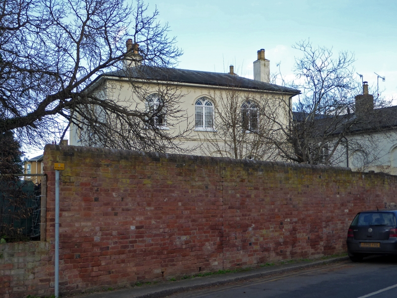
House. Early to mid-C19. Stucco with slate roof. Gothick style. Two storeys, two bays. Facade flanked by pilaster strips with tracery panels. Band of Tudor arches separated by pendant bosses below eaves. Verandah over ground floor with iron supports. Right-hand bay has timber canted bay window on ground floor. First floor windows have Tudor-arched heads with hoodmoulds, a timber mullion which branches to form Y-tracery, and a transom. Glazed with margin panes. Door, in left-hand bay, has Gothick mouldings and a fanlight within a Tudor-arched head. Chimney near centre of ridge.
Listing NGR: SO8523549237
External links are from the relevant listing authority and, where applicable, Wikidata. Wikidata IDs may be related buildings as well as this specific building. If you want to add or update a link, you will need to do so by editing the Wikidata entry.


Other nearby listed buildings
