Approximate Location Map
Large Map »
Latitude: 51.3882 / 51°23'17"N
Longitude: 1.3829 / 1°22'58"E
OS Eastings: 635460
OS Northings: 170891
OS Grid: TR354708
Mapcode National: GBR WZS.VVK
Mapcode Global: VHLG6.XCFN
Plus Code: 9F3399QM+74
Entry Name: 4, Hawley Street
Listing Date: 22 February 1973
Grade: II
Source: Historic England
Source ID: 1351102
English Heritage Legacy ID: 356576
ID on this website: 101351102
Location: Margate, Thanet, Kent, CT9
County: Kent
District: Thanet
Electoral Ward/Division: Margate Central
Parish: Non Civil Parish
Built-Up Area: Margate
Traditional County: Kent
Lieutenancy Area (Ceremonial County): Kent
Tagged with: Building
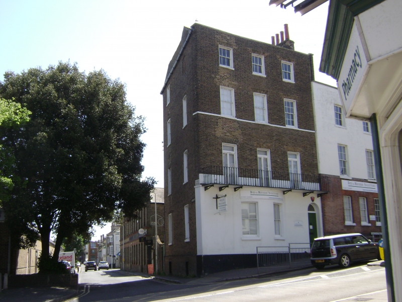
HAWLEY STREET
1.
1380
(East Side )
No 4
TR 3570 NW 1/18
II GV
2.
Early C19. 4 storeys and basement stock brick. Stone coping. Stringcourse.
3 sashes with glazing bars intact and stone cills. 1st floor cast iron balcony.
The ground floor has a 2 light curved bay and right side round-headed doorcase.
Nos 2 & 4 form a group with Nos 24 and 25 Cecil Square
Listing NGR: TR3546070891
External links are from the relevant listing authority and, where applicable, Wikidata. Wikidata IDs may be related buildings as well as this specific building. If you want to add or update a link, you will need to do so by editing the Wikidata entry.


Other nearby listed buildings
