Approximate Location Map
Large Map »
Latitude: 51.2802 / 51°16'48"N
Longitude: 1.0779 / 1°4'40"E
OS Eastings: 614751
OS Northings: 157946
OS Grid: TR147579
Mapcode National: GBR TY2.PBD
Mapcode Global: VHLGM.M2PY
Plus Code: 9F3373JH+35
Entry Name: 56 and 57, St Peter's Street
Listing Date: 7 September 1973
Grade: II
Source: Historic England
Source ID: 1358675
English Heritage Legacy ID: 442983
ID on this website: 101358675
Location: Canterbury, Kent, CT1
County: Kent
District: Canterbury
Electoral Ward/Division: Westgate
Parish: Non Civil Parish
Built-Up Area: Canterbury
Traditional County: Kent
Lieutenancy Area (Ceremonial County): Kent
Tagged with: Building
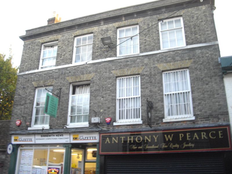
1.
944 ST PETER'S STREET
Nos 56 and 57
TR 1457 NE 4/692
II GV
2.
Early C19. 2 parallel ranges. 3 storeys buff brick. Old tiled roof. Stone
parapet with dropped moulded cornice. Stringcourse. 4 sashes with glazing
bars intact. Later shop front.
Nos 49 to 60 (consec), Methodist Church and forecourt to Methodist Church
form a group.
Listing NGR: TR1474857947
External links are from the relevant listing authority and, where applicable, Wikidata. Wikidata IDs may be related buildings as well as this specific building. If you want to add or update a link, you will need to do so by editing the Wikidata entry.


Other nearby listed buildings
