Approximate Location Map
Large Map »
Latitude: 52.1868 / 52°11'12"N
Longitude: -2.2166 / 2°12'59"W
OS Eastings: 385287
OS Northings: 254306
OS Grid: SO852543
Mapcode National: GBR 1G4.Y4D
Mapcode Global: VH92T.J9JF
Plus Code: 9C4V5QPM+P9
Entry Name: Haresfield House
Listing Date: 22 May 1954
Grade: II
Source: Historic England
Source ID: 1359576
English Heritage Legacy ID: 488515
ID on this website: 101359576
Location: Diglis, Worcester, Worcestershire, WR5
County: Worcestershire
District: Worcester
Electoral Ward/Division: Cathedral
Parish: Non Civil Parish
Built-Up Area: Worcester
Traditional County: Worcestershire
Lieutenancy Area (Ceremonial County): Worcestershire
Church of England Parish: Worcester, St Martin with St Peter and Whittington
Church of England Diocese: Worcester
Tagged with: House
WORCESTER
SO8554SW BATH ROAD
620-1/20/41 (West side)
22/5/54 Nos.8-10
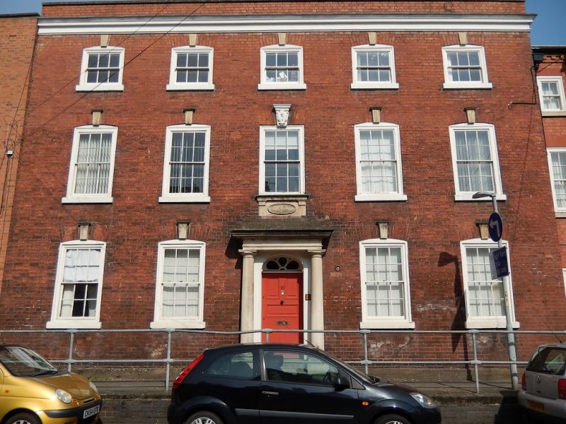
Haresfield House
GV II
House, now surgery and flats. Inscribed and dated JS 1740 above
door, with later additions and alterations including those c1980s
to rear. Reddish-brown brick in Flemish bond with ashlar
keystones, sills, porch, cornice and copings; slate roof. 3
storeys, 5 first-floor windows. Ground and first floors have 6/6
sashes; second floor has 3/3 sashes; all in near-flush frames
with sills and cambered arches with fluted keystones, central
first-floor window has acanthus decoration to keystone, moulded
sill and apron with date. Central entrance: 2 roll-edged steps to
5-panel door, the lower panels flush beaded, the upper panels
raised and fielded, fanlight with petal motif; doorcase has 3/4
engaged Doric columns with frieze and cornice. Crowning renewed
frieze and moulded cornice, low coped parapet.
INTERIOR: retains original panelling and joinery including
panelled shutters and moulded cornices.
City of Worcester Award, 1989.Nos 6, 10, 16, 18 and Nos 11-23
(odd) Bath Road form a group together with Nos 117 and 119
Sidbury (qqv).
External links are from the relevant listing authority and, where applicable, Wikidata. Wikidata IDs may be related buildings as well as this specific building. If you want to add or update a link, you will need to do so by editing the Wikidata entry.


Other nearby listed buildings
