Approximate Location Map
Large Map »
Latitude: 53.3654 / 53°21'55"N
Longitude: -0.011 / 0°0'39"W
OS Eastings: 532448
OS Northings: 387239
OS Grid: TF324872
Mapcode National: GBR XYCJ.F9
Mapcode Global: WHHJS.SNZV
Plus Code: 9C5X9X8Q+5J
Entry Name: Thornton House
Listing Date: 2 November 1954
Grade: II*
Source: Historic England
Source ID: 1359929
English Heritage Legacy ID: 195054
ID on this website: 101359929
Location: Troutbeck, East Lindsey, Lincolnshire, LN11
County: Lincolnshire
District: East Lindsey
Civil Parish: Louth
Built-Up Area: Louth
Traditional County: Lincolnshire
Lieutenancy Area (Ceremonial County): Lincolnshire
Church of England Parish: Louth
Church of England Diocese: Lincoln
Tagged with: House
This list entry was subject to a Minor Amendment on 14 May 2021 to reformat the text to current standards
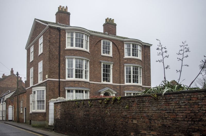
TF 3287
2/4
WESTGATE (south side)
No 25 (Thornton House)
2.11.54.
GV
II*
Later C18. Five storey brick house standing gable end to road; shallow pitched slate roof. Entrance front, west, two three storey segmental bays, three-light hung sash windows. The central section is slighty recessed and has a semi-circular arched head reaching to the eaves cornice. The central windows, second floor wide architrave with segmental head; first floor architrave with two consoles and cornice. Central entrance, two reeded columns, triangular pediment broken over semi-circular head of doorway, plain reveals, panelled door. A continuous band links the cills of first floor windows of the west front and north end. The eaves cornice is also carried on and with a moulding on the gable forms a pediment above the north (road) end. In the road end are two windows to each floor, sash in wide wooden cases flush with the wall face, flat arched heads. The right hand ground floor window is a bow of similar proportions to those on the west front. Two chanelled stone gate piers, brick wall.
Nos 25, 29 to 31 (odd), Westgate House, The Limes and Nos 43 to 47 (odd) form
a group.
Listing NGR: TF3244887239
External links are from the relevant listing authority and, where applicable, Wikidata. Wikidata IDs may be related buildings as well as this specific building. If you want to add or update a link, you will need to do so by editing the Wikidata entry.


Other nearby listed buildings
