Approximate Location Map
Large Map »
Latitude: 51.1964 / 51°11'47"N
Longitude: 0.275 / 0°16'30"E
OS Eastings: 559054
OS Northings: 146596
OS Grid: TQ590465
Mapcode National: GBR MP0.Y23
Mapcode Global: VHHQ6.Q684
Plus Code: 9F3257WG+H2
Entry Name: 124, High Street
Listing Date: 8 May 1950
Grade: II*
Source: Historic England
Source ID: 1363400
English Heritage Legacy ID: 178694
ID on this website: 101363400
Location: Tonbridge, Tonbridge and Malling, Kent, TN9
County: Kent
District: Tonbridge and Malling
Electoral Ward/Division: Castle
Parish: Non Civil Parish
Built-Up Area: Tonbridge
Traditional County: Kent
Lieutenancy Area (Ceremonial County): Kent
Church of England Parish: Tonbridge St Peter and St Paul
Church of England Diocese: Rochester
Tagged with: Building
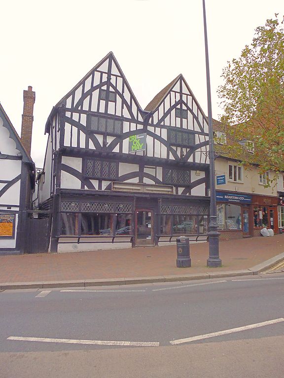
1. HIGH STREET
1732 (West Side)
No 124
TO 5946 NW 3/24 8.5.50.
II* GV
2.
Another good example of a restored Cl5 timber-framed house. 4 storeys.
2 windows. First and second floors overhang on the protruding ends of
the floor Joists and brackets but the ground floor has been underbuilt-and
now consists of a modern shop front. Wide curved braces curving outwards
on first and second floors with small 4-light oriel windows not apparently
original. The attic floor has 2 gables, each with curved braces arranged in
the opposite pattern to those below, the ends meeting and forming a V
upside down. Each gable has 2 very small. casement windows, separated in
each case by an upright timber.
Nos 122, 124, 126, 126A & 128 together form a group
Listing NGR: TQ5905446596
External links are from the relevant listing authority and, where applicable, Wikidata. Wikidata IDs may be related buildings as well as this specific building. If you want to add or update a link, you will need to do so by editing the Wikidata entry.


Other nearby listed buildings
