Approximate Location Map
Large Map »
Latitude: 53.1903 / 53°11'24"N
Longitude: -1.6184 / 1°37'6"W
OS Eastings: 425593
OS Northings: 365977
OS Grid: SK255659
Mapcode National: GBR 581.ZM9
Mapcode Global: WHCDG.32LL
Plus Code: 9C5W59RJ+4J
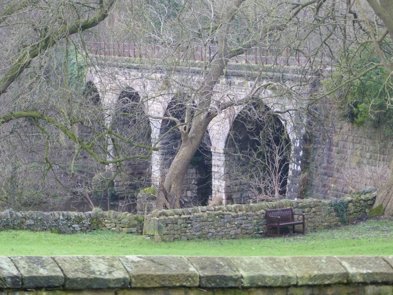
Entry Name: Railway Viaduct, Embank ment and Overbridge to the East of Church Farm
Listing Date: 7 March 1986
Grade: II
Source: Historic England
Source ID: 1367028
English Heritage Legacy ID: 81747
ID on this website: 101367028
Location: Rowsley, Derbyshire Dales, Derbyshire, DE4
County: Derbyshire
District: Derbyshire Dales
Civil Parish: Rowsley
Traditional County: Derbyshire
Lieutenancy Area (Ceremonial County): Derbyshire
Church of England Parish: Rowsley St Katherine
Church of England Diocese: Derby
Tagged with: Architectural structure Railway viaduct
This list entry was subject to a Minor Amendment on 2 November 2022 to correct a typo in the description and to reformat the text to current standards
SK 26 NE
5/180
PARISH OF ROWSLEY
OFF CHURCH LANE (East Side)
Railway Viaduct, Embank ment and Overbridge to the East of Church Farm
7.3.86
II
This asset was previously listed twice also under List entry 1248289. This entry was removed from the List on 01/12/2014.
Railway viaduct, embankment and overbridge. 1851-2, to carry the Rowsley to Buxton extension of the Midland Railway over the River Derwent. Massive coursed gritstone with rock-faced dressings. Slightly curved viaduct section to east end comprising four semi-circular headed arches, springing from rock-faced padstones, set on rectangular piers rising from rounded cutwaters. A shallow parapet sits on a plain band course, with plain C20 railings above. On the northern side, at either end of the viaduct, shallow raking buttresses support the abutments. Further to the west, a substantial embankment is faced with masonry on its northern face. This embankment is pierced at the western end by a narrow stilted semi-circular arched opening over a trackway. The arch is flanked by shallow pilaster-like buttresses, extending from which are downward sloping splayed and coped abutments, terminating at plain stone piers. See also Matlock Urban District.
Listing NGR: SK2559465979
External links are from the relevant listing authority and, where applicable, Wikidata. Wikidata IDs may be related buildings as well as this specific building. If you want to add or update a link, you will need to do so by editing the Wikidata entry.


Other nearby listed buildings
