Approximate Location Map
Large Map »
Latitude: 51.4442 / 51°26'39"N
Longitude: 0.3694 / 0°22'9"E
OS Eastings: 564754
OS Northings: 174354
OS Grid: TQ647743
Mapcode National: GBR NMK.J5J
Mapcode Global: VHJLC.CY3R
Plus Code: 9F32C9V9+MP
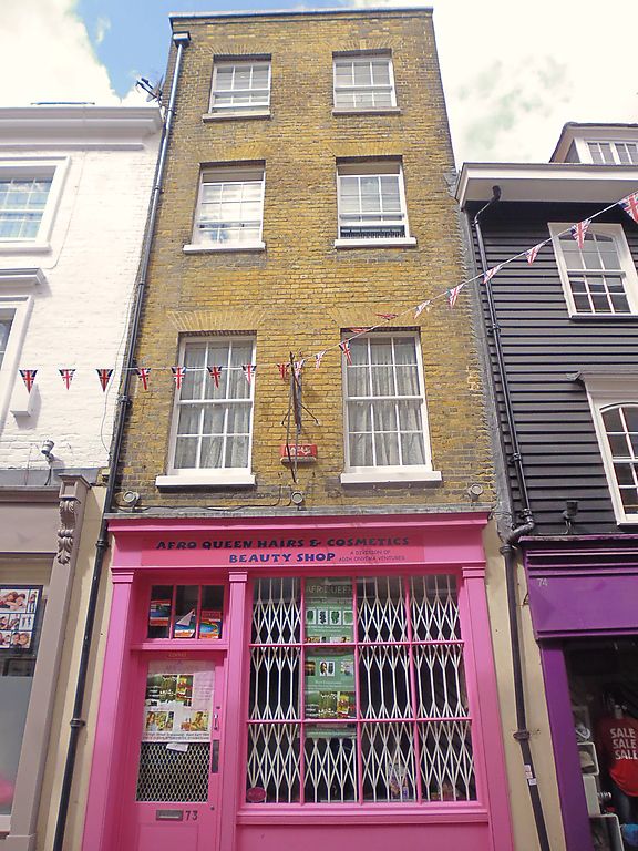
Entry Name: 73, High Street
Listing Date: 3 July 1975
Grade: II
Source: Historic England
Source ID: 1367087
English Heritage Legacy ID: 356366
ID on this website: 101367087
Location: Gravesend, Gravesham, Kent, DA11
County: Kent
District: Gravesham
Electoral Ward/Division: Pelham
Parish: Non Civil Parish
Built-Up Area: Gravesend
Traditional County: Kent
Lieutenancy Area (Ceremonial County): Kent
Church of England Parish: Gravesend St George
Church of England Diocese: Rochester
Tagged with: Building
1.
5277 HIGH STREET
(West Side)
No 73
TQ 6474 SE 1/104
II GV
2.
Early C19. 4 storeys stock brick. 2 sashes with glazing bars intact. Modern
shopfront.
Nos 65 to 74 (consec) form a group. (Nos 65 to 69 (consec) and 74 are local interest
buildings.
Listing NGR: TQ6475174359
External links are from the relevant listing authority and, where applicable, Wikidata. Wikidata IDs may be related buildings as well as this specific building. If you want to add or update a link, you will need to do so by editing the Wikidata entry.


Other nearby listed buildings
