Approximate Location Map
Large Map »
Latitude: 51.4446 / 51°26'40"N
Longitude: 0.3694 / 0°22'9"E
OS Eastings: 564757
OS Northings: 174398
OS Grid: TQ647743
Mapcode National: GBR NMK.B7L
Mapcode Global: VHJLC.CY4F
Plus Code: 9F32C9V9+RQ
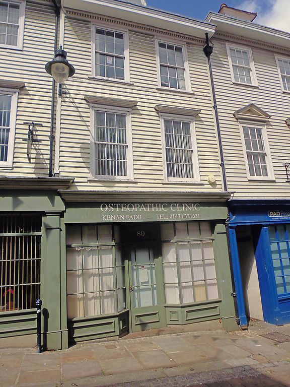
Entry Name: 80, High Street
Listing Date: 19 March 1974
Grade: II*
Source: Historic England
Source ID: 1367090
English Heritage Legacy ID: 356371
ID on this website: 101367090
Location: Gravesend, Gravesham, Kent, DA11
County: Kent
District: Gravesham
Electoral Ward/Division: Pelham
Parish: Non Civil Parish
Built-Up Area: Gravesend
Traditional County: Kent
Lieutenancy Area (Ceremonial County): Kent
Church of England Parish: Gravesend St George
Church of England Diocese: Rochester
Tagged with: Building
TQ 6474
742/1/110
HIGH STREET (West side),
No 80
19.3.74
GV II*
Early to mid C18. 3 storeys weatherboarded, Old tiled roof with 1 original curved dormer. Wide wooden moulded and dentilled eaves cornice. 2 sashes with glazing bars intact. Cornices to 1st floor windows. Modern shopfront. Nos 77 to 83 (consec) and 77A form a group.
Listing NGR: TQ6475974396
External links are from the relevant listing authority and, where applicable, Wikidata. Wikidata IDs may be related buildings as well as this specific building. If you want to add or update a link, you will need to do so by editing the Wikidata entry.


Other nearby listed buildings
