Approximate Location Map
Large Map »
Latitude: 51.4439 / 51°26'38"N
Longitude: 0.3353 / 0°20'7"E
OS Eastings: 562392
OS Northings: 174244
OS Grid: TQ623742
Mapcode National: GBR YV.R7N
Mapcode Global: VHHNW.RYNZ
Plus Code: 9F32C8VP+H4
Entry Name: 1 and 2, Granby Place
Listing Date: 26 July 1983
Grade: II
Source: Historic England
Source ID: 1367458
English Heritage Legacy ID: 356843
ID on this website: 101367458
Location: Northfleet, Gravesham, Kent, DA11
County: Kent
District: Gravesham
Electoral Ward/Division: Northfleet North
Parish: Non Civil Parish
Built-Up Area: Northfleet
Traditional County: Kent
Lieutenancy Area (Ceremonial County): Kent
Church of England Parish: Northfleet and Rosherville
Church of England Diocese: Rochester
Tagged with: Building
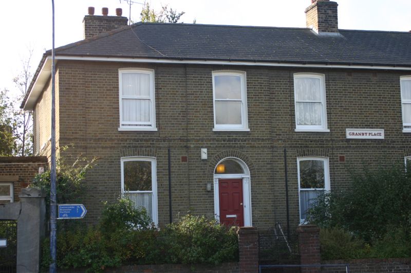
TQ 67 SW NORTHFLEET GRANBY PLACE
1/112
Nos 1 and 2
II
Circa 1830. A pair of semi-detached, 2-storey houses in yellow brick with hipped
slate roof. Six sash windows. Two round-headed doorways with reeded pilasters,
semi-circular fanlights and doors of 6 moulded and fielded panels.
Listing NGR: TQ6239174233
External links are from the relevant listing authority and, where applicable, Wikidata. Wikidata IDs may be related buildings as well as this specific building. If you want to add or update a link, you will need to do so by editing the Wikidata entry.


Other nearby listed buildings
