Approximate Location Map
Large Map »
Latitude: 53.1916 / 53°11'29"N
Longitude: -2.871 / 2°52'15"W
OS Eastings: 341899
OS Northings: 366411
OS Grid: SJ418664
Mapcode National: GBR 7B.2YZL
Mapcode Global: WH88F.W10K
Plus Code: 9C5V54RH+JH
Entry Name: Cemetery wall of former Leprosy Hospital of St Giles
Listing Date: 23 July 1998
Grade: II
Source: Historic England
Source ID: 1375952
English Heritage Legacy ID: 469931
ID on this website: 101375952
Location: Boughton, Cheshire West and Chester, Cheshire, CH3
County: Cheshire West and Chester
Electoral Ward/Division: Boughton
Parish: Non Civil Parish
Built-Up Area: Chester
Traditional County: Cheshire
Lieutenancy Area (Ceremonial County): Cheshire
Church of England Parish: Chester St Paul
Church of England Diocese: Chester
Tagged with: Wall
This list entry was subject to a Minor Amendment on 17 August 2022 to correct the name and reformat the text to current standards
SJ4166
1932-1/6/200
CHESTER CITY (EM)
THE MOUNT (north side)
Cemetery wall of former Leprosy Hospital of St Giles
(Formerly listed as Cemetery wall of former Leper Hospital of St Giles)
GV
II
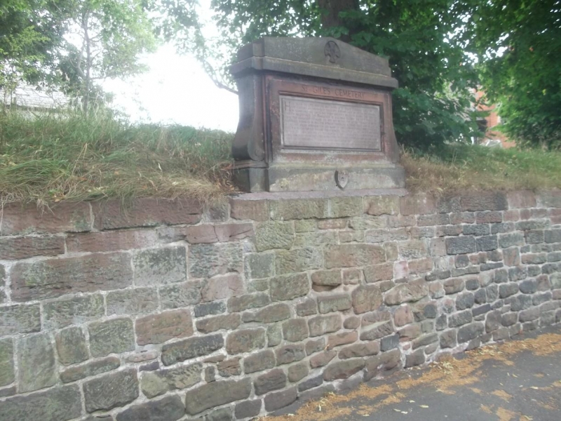
Retaining wall of cemetery. Early C12, periodically repaired. Coursed red sandstone rubble. Oval in plan. 36 x 24m, approximately 1.6m high. The side to Christleton Road is almost straight. The wall is battered. A stone tablet mounted above the south side of wall to Christleton Road is inscribed "SAINT GILES CEMETERY: HERE STOOD THE LEPER HOSPITAL AND CHAPEL OF SAINT GILES FOUNDED EARLY IN THE TWELFTH CENTURY AND ENDOWED BY SUCCESSIVE NORMAN EARLS OF CHESTER. THEY REMAINED IN CONSTANT USE UNTIL 1645 WHEN DEFENSIVE MEASURES NECESSITATED THE DEMOLITION OF BUILDINGS OUTSIDE THE CITY WALLS. THE CEMETERY REMAINED TO MARK THE SITE AND IN TIME THE LITTLE VILLAGE OF SPITAL CLUSTERED AROUND IT. IN 1644 UNTIL THE ROYALIST DEFENDERS SURRENDERED HERE IT WAS ALSO USED FOR VICTIMS OF THE PLAGUES WHICH RAVAGED THE CITY IN THE 16TH AND 17TH CENTURIES. BEING EXTRA PAROCHIAL THE SITE WAS GRANTED TO THE CORPORATION BY CHARLES II IN 1685 AS A BURIAL GROUND AND, THOUGH FOR A PERIOD IN THE CHARGE OF ST.JOHN'S PARISH, IT REMAINS IN THEIR HANDS. WHEN THE PROTESTANT MARTYR WAS BURNED AT THE STAKE ON GALLOWS HILL CLOSE BY HIS ASHES WERE COLLECTED BY HIS FRIENDS AND BURIED HERE. THE LAST BURIAL TOOK PLACE IN 1854".
The rear of the tablet is inscribed "I H S : MANY UNKNOWN ARE BURIED HERE NOTABLY THE LEPERS FROM THE 12TH CENTURY TO 1643, SOLDIERS WHO FELL IN THE BATTLE OF GREAT BOUGHTON 1644 AND NUMEROUS VICTIMS OF THE PLAGUE".
The cemetery wall encloses a cemetery containing a number of damaged table tombs, mostly C19 in date, none of which are included in this item.
Listing NGR: SJ4189966410
External links are from the relevant listing authority and, where applicable, Wikidata. Wikidata IDs may be related buildings as well as this specific building. If you want to add or update a link, you will need to do so by editing the Wikidata entry.


Other nearby listed buildings
