Approximate Location Map
Large Map »
Latitude: 52.2126 / 52°12'45"N
Longitude: -1.6223 / 1°37'20"W
OS Eastings: 425902
OS Northings: 257217
OS Grid: SP259572
Mapcode National: GBR 5N1.BN2
Mapcode Global: VHBXV.TNQ6
Plus Code: 9C4W697H+23
Entry Name: Charlecote Mill and wall to south
Listing Date: 28 October 1999
Last Amended: 7 December 2018
Grade: II*
Source: Historic England
Source ID: 1382109
English Heritage Legacy ID: 482474
ID on this website: 101382109
Location: Hampton Lucy, Stratford-on-Avon, Warwickshire, CV35
County: Warwickshire
District: Stratford-on-Avon
Civil Parish: Charlecote
Traditional County: Warwickshire
Lieutenancy Area (Ceremonial County): Warwickshire
Church of England Parish: Charlecote St Leonard
Church of England Diocese: Coventry
Tagged with: Watermill Mill building
Water mill, for corn and later animal feed, then restored as a corn mill. Mid- to late C18 with some C19 alterations.
Water mill, for corn and later animal feed, then restored as a corn mill. Mid- to late C18 with some C19 alterations.
MATERIALS: brick laid to Flemish stretcher bond; gabled plain clay tile roof.
PLAN: the mill stands on an island in the mill race, the water passing both sides to feed a wheel at either end. The building has a T-plan, the main range orientated roughly east-west, the main elevation to the south, with two undershot wheels and associated machinery flanking the broad, central working area.
EXTERIOR: the building is of two storeys and attic; the main elevation is a symmetrical 5-window range, with a top cogged cornice. The central entrance door and loading door above are set in a segmental-headed openings, with a heavy, pegged frame to the paired and studded plank doors. The ground floor has segmental-headed windows with two-light small-paned glazing; there are four similar first-floor windows, two with opening casements. A weatherboarded, gabled lucombe with a two-light, small-paned casement window extends over the entrance bay. The left (western) return has a round-arched doorway set centrally, with paired plank doors to the wheel chamber. Above is blind except for a three-light casement window high in the gable. The rear has had its eaves raised in the later C19, probably to accommodate extra grain. The projecting central wing has a segmental-headed window with three-light frame and a small-paned opening casement to each of the ground floor, first floor and attic. To either side is a pegged doorway in a segmental opening, with a studded plank door; the outer end of each bay houses the wheel chamber, denoted by a wide segmental-headed opening, with each having a timber lintel and paired plank doors. Above is a small paned opening casement to the first floor, and to the west end is a small opening with projecting iron shaft and wheel above the wheel chamber.
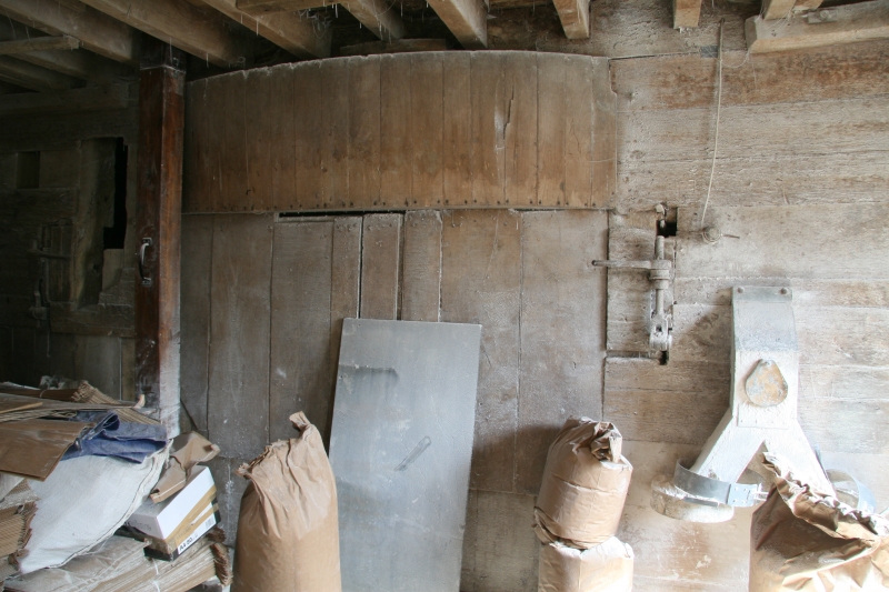
INTERIOR: the ground floor has a stone flag floor; very heavy, chamfered beams with runout stops support plank floors, all in elm, to the upper floors. The upper floors are reached by a straight ladder stair to each. The building has a heavy queen-post roof, the openings between the queen posts wide and high enough to allow sack trollies to pass through. The apex of each truss is supported by a jowled king post set on the collar. The mill houses two undershot water wheels, one at either end of the building, their elements dating largely from the C19. The paddles and associated sluice gates were largely renewed as part of the 1970s repairs. The wooden upright shafts and wheels are held within two heavily-constructed timber hurst frames; these have boarded cladding to their inner ground-floor faces with meal spouts taking flour from first-floor millstones, and segmental extensions to house the width of the spur wheels. Each wheel drives two pairs of stones on the milling floor. Deep grain bins between the first and attic floors are accessed through hatches on the attic floor, the hatches having studded leather hinges. The entire original roof structure remains in place; the raised section to rear rises on timbers set above earlier roof. There are various scratched and painted inscriptions of the initials or names of past millers throughout the building, together with taper marks and two daisy wheels.
SUBSIDIARY FEATURES: to the south of the mill building is a PARAPET WALL at the end of the island. The wall is constructed from brick, the upper section battered, with a narrow, half-round mortar capping.
Domesday records that there were two mills in Charlecote in 1066, and one in adjoining Hampton Lucy, possibly on or near the site of the present Charlecote Mill, which straddles the border between the two parishes. Charlecote Mill, and the adjacent mill house, were constructed by the Lucy estate. The earliest reference so far discovered to a mill on the present site dates from 1728, at which point the miller was Stephen Lewis. The mill had certainly been established for some time, as significant repairs were carried out only three years later, involving work by masons, millwrights and blacksmiths, costing over £193 (equivalent to around £30,000 in 2018). Charlecote Mill is depicted on a map of the Lucy estate in 1736, which shows the watercourse in the same configuration as at present; the footprint of the mill depicted differs slightly from the present building, but already had two waterwheels, one at either end of the structure. The watercourses were repaired in 1753, and the sack hoist and flour dresser were installed in this period. A further estate map of 1791 shows the watercourse and mill building in the same configuration as in 1736. A millstone on the middle floor of the present mill is inscribed ‘this bed stone was put in 1806’ suggesting that the building underwent further work at this time. Under miller William Witherington, who worked the mill from 1845-1864, some of the gearwheels and the rims of the waterwheels were converted from timber to iron. Later in the C19, the rear roof slope was raised, probably to accommodate greater quantities of grain, and the remaining parts of the timber waterwheels, with the exception of the paddles, were replaced in iron. In the years between the First and Second World Wars, the mill was primarily used for grinding animal feed, and was taken over by Newbery and Son, a firm of farmers, millers and agricultural contractors. By about 1939, the waterwheels were in a poor state of repair, and were no longer used for milling, though the mill remained in use, and during the war, the west wheel was rigged up to drive the sack hoist, with animal feed being milled by modern machinery driven initially by a tractor and later electrically. Milling ceased on the site in about 1960, when Newbery and Son left. Basic repairs were carried out in 1978; the west wheel was made to turn when the BBC used the mill as a location for filming an adaptation of George Eliot’s The Mill on the Floss. After this, Sir Edmund Fairfax-Lucy, in whose family the ownership of the mill remains, sought to rent the mill to a new miller, John Bedington, by whom it was repaired, the modern interventions largely removed, and it was brought back into working order, grinding corn again from 1981. The mill has been run as a full-time business, producing mainly wholemeal flour, since 1983, in which use it remains (2018).
Charlecote Mill, a C18 and C19 corn mill, is listed at Grade II*, for the following principal reasons:
Architectural interest:
* as a well-planned, symmetrical, multi-story watermill for corn, the building is very well preserved and entirely legible;
* it retains its historic machinery in working order, with water wheels at both ends of the building each driving two pairs of millstones.
Historic interest:
* the mill is still in use as a corn mill, using its extensive historic machinery, and has been so apart from a short hiatus in the later C20, since its construction in the C18.
Group value:
* with the attached Mill House (Grade II), and the registered park and garden Charlecote Park (Grade I) a short distance away, whose estate the mill was built to serve, and in whose ownership it remains.
External links are from the relevant listing authority and, where applicable, Wikidata. Wikidata IDs may be related buildings as well as this specific building. If you want to add or update a link, you will need to do so by editing the Wikidata entry.


Other nearby listed buildings
