Approximate Location Map
Large Map »
Latitude: 51.4498 / 51°26'59"N
Longitude: -0.0857 / 0°5'8"W
OS Eastings: 533115
OS Northings: 174048
OS Grid: TQ331740
Mapcode National: GBR HL.F28
Mapcode Global: VHGR6.GTJG
Plus Code: 9C3XCWX7+WP
Entry Name: The Hollies the Laurels
Listing Date: 27 September 1972
Last Amended: 17 September 1998
Grade: II
Source: Historic England
Source ID: 1385481
English Heritage Legacy ID: 470880
ID on this website: 101385481
Location: Dulwich Village, Southwark, London, SE21
County: London
District: Southwark
Electoral Ward/Division: Village
Parish: Non Civil Parish
Built-Up Area: Southwark
Traditional County: Surrey
Lieutenancy Area (Ceremonial County): Greater London
Church of England Parish: Dulwich St Barnabas
Church of England Diocese: Southwark
Tagged with: Architectural structure
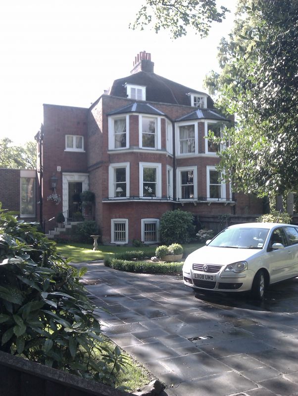
SOUTHWARK
TQ3374SW DULWICH VILLAGE
636-1/56/295 (West side)
27/09/72 Nos.60 AND 62
The Laurels (No.60) and The Hollies
(No.62)
(Formerly Listed as:
DULWICH VILLAGE
(West side)
Nos.60 AND 62)
II
Pair of semi-detached houses,. Mid C18 with later alterations.
Red brick with hipped, tiled mansard roof with dormers and
central chimney stack behind coped parapet.
2 storeys, half-exposed basement and attic, 1 main bay each,
with recessed 1-bay entrance extensions to sides. Steps up to
doors in timber doorcase with alternate block surround, No.60
with porch and iron rail. Main section has later, full-height
canted bay windows with slated roofs. Plate-glass boxed sash
windows, those on ground floor with cast-iron guards.
INTERIOR: not inspected.
Listing NGR: TQ3311574048
External links are from the relevant listing authority and, where applicable, Wikidata. Wikidata IDs may be related buildings as well as this specific building. If you want to add or update a link, you will need to do so by editing the Wikidata entry.


Other nearby listed buildings
