Approximate Location Map
Large Map »
Latitude: 51.5003 / 51°30'0"N
Longitude: -0.0639 / 0°3'50"W
OS Eastings: 534482
OS Northings: 179702
OS Grid: TQ344797
Mapcode National: GBR YJ.SC
Mapcode Global: VHGR0.VK28
Plus Code: 9C3XGW2P+4C
Entry Name: 96 Bermondsey Wall East
Listing Date: 1 July 1983
Last Amended: 17 September 1998
Grade: II
Source: Historic England
Source ID: 1385524
English Heritage Legacy ID: 470923
ID on this website: 101385524
Location: Wapping, Southwark, London, SE16
County: London
District: Southwark
Electoral Ward/Division: Riverside
Parish: Non Civil Parish
Built-Up Area: Southwark
Traditional County: Surrey
Lieutenancy Area (Ceremonial County): Greater London
Church of England Parish: Bermondsey St James with Christ Church
Church of England Diocese: Southwark
Tagged with: Building
This list entry was subject to a Minor Amendment on 10 March 2023 to amend the name and address and to reformat the text to current standards
TQ3479
636-1/6/339
SOUTHWARK
BERMONDSEY WALL EAST
No 96
(Formerly listed as FARNCOMBE STREET (East side) No.48, previously listed as: FARNCOMBE STREET, Bermondsey Thames Water Authority Office)
01/07/83
II
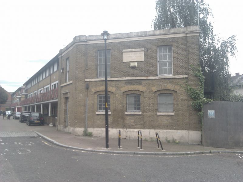
Former office. Dated 1822. For the sewer pumping station (now demolished). Stock brick with stone dressings, shallow stone frieze, cornice and blocking course.
Two-storey wedge-shaped corner building with three-bay front. Brick quoin pilasters. Ground floor has small segmental gauged-brick arched windows set in segmental-arched panels reaching down to stone plinth. Flat gauged-brick arches to two first-floor windows (C20 metal casements) flanking Portland stone Doric plaque inscribed: "Sewers Surrey and Kent, Duffield Sluice, 1822". Painted stone plat band between floors. One-bay splayed return to left has similar details; blocked doorway with cornice on console brackets.
INTERIOR: not inspected.
An early sewerage building, predating the present system, begun in 1858. Dates from first phase of dock expansion.
Listing NGR: TQ3448279702
External links are from the relevant listing authority and, where applicable, Wikidata. Wikidata IDs may be related buildings as well as this specific building. If you want to add or update a link, you will need to do so by editing the Wikidata entry.


Other nearby listed buildings
