Approximate Location Map
Large Map »
Latitude: 51.4735 / 51°28'24"N
Longitude: -0.0629 / 0°3'46"W
OS Eastings: 534633
OS Northings: 176729
OS Grid: TQ346767
Mapcode National: GBR ZT.0Y
Mapcode Global: VHGR6.V7M7
Plus Code: 9C3XFWFP+CV
Entry Name: 4 Woods Road
Listing Date: 27 September 1972
Last Amended: 17 September 1998
Grade: II
Source: Historic England
Source ID: 1386054
English Heritage Legacy ID: 471475
ID on this website: 101386054
Location: Peckham, Southwark, London, SE15
County: London
District: Southwark
Electoral Ward/Division: Nunhead
Parish: Non Civil Parish
Built-Up Area: Southwark
Traditional County: Surrey
Lieutenancy Area (Ceremonial County): Greater London
Church of England Parish: Peckham St Mary Magdalene
Church of England Diocese: Southwark
Tagged with: Building
This list entry was subject to a Minor Amendment on 2 November 2023 to amend the name, address and reformat the text to current standards
TQ3476
636-1/12/867
SOUTHWARK
WOODS ROAD (West side)
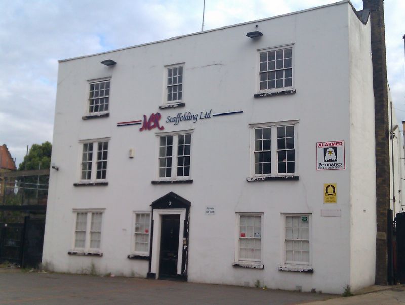
No 4
(Formerly listed as No.2, previously listed as: HARDERS ROAD (West side) No.2)
27/09/72
II
House, now offices. Later C17, altered c1820 and later. White painted render to original brick structure; roof obscured behind later parapet.
Three storeys, three bays with later extension to rear. Central door with shallow segmental pediment and moulded shouldered architrave. Varying windows are all sashes with glazing bars. Those at left-hand ground-floor bay and on first floor are two-light, with timber pilaster jambs and mullions. Later pair to right of door, and one immediately to left of door (matching one to right now blocked?). Second-floor windows have timber surrounds, the central one 12 panes, those to outer bays 16 panes.
INTERIOR: has original timber beams visible on all floors. One wainscoted room on first floor; panelled landing and 1st-floor stairway.
Listing NGR: TQ3463376729
External links are from the relevant listing authority and, where applicable, Wikidata. Wikidata IDs may be related buildings as well as this specific building. If you want to add or update a link, you will need to do so by editing the Wikidata entry.


Other nearby listed buildings
