Approximate Location Map
Large Map »
Latitude: 51.9067 / 51°54'24"N
Longitude: -2.0633 / 2°3'47"W
OS Eastings: 395744
OS Northings: 223129
OS Grid: SO957231
Mapcode National: GBR 2M5.F5P
Mapcode Global: VHB1Q.6B3P
Plus Code: 9C3VWW4P+MM
Entry Name: Southwood Lodge and Attached Wall
Listing Date: 5 May 1972
Grade: II
Source: Historic England
Source ID: 1387602
English Heritage Legacy ID: 475577
ID on this website: 101387602
Location: Pittville, Cheltenham, Gloucestershire, GL52
County: Gloucestershire
District: Cheltenham
Electoral Ward/Division: Pittville
Parish: Non Civil Parish
Built-Up Area: Cheltenham
Traditional County: Gloucestershire
Lieutenancy Area (Ceremonial County): Gloucestershire
Church of England Parish: Cheltenham Holy Trinity
Church of England Diocese: Gloucester
Tagged with: Architectural structure
CHELTENHAM
SO9523SE PRESTBURY ROAD
630-1/7/711 (North side)
05/05/72 No.74
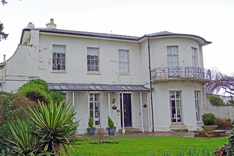
Southwood Lodge and attached wall
II
Villa, now funeral home and attached wall. c1830, shown on
Merrett's 1834 Map. Stucco over brick with slate roof, hipped
to front and double pitch to rear, end stucco stacks with iron
verandah and balcony.
EXTERIOR: 2 storeys, 3+2 first-floor windows, those to right
in full-height bow. Single-storey outshut to rear at left.
First floor has three 6/6 sashes, otherwise ground floor and
bow have 6-pane French windows with divided overlights and
margin-lights; all in plain reveals and with sills. Central
entrance a 6-raised-and-fielded-panel door with lozenge motif
to frieze and overlight. Further angled range set back to
right has 1 first-floor window a 6/6 sash. Rear retains 6/6
sashes.
INTERIOR: not inspected.
SUBSIDIARY FEATURES: Ground floor verandah to left has column
cluster uprights and openwork frieze; balcony to first floor
of bow has web motif. Coped wall at left ramped downwards.
(Merrett HS: Plan of the Town of Cheltenham: 1834-).
Listing NGR: SO9574423129
External links are from the relevant listing authority and, where applicable, Wikidata. Wikidata IDs may be related buildings as well as this specific building. If you want to add or update a link, you will need to do so by editing the Wikidata entry.


Other nearby listed buildings
