Approximate Location Map
Large Map »
Latitude: 51.8957 / 51°53'44"N
Longitude: -2.0688 / 2°4'7"W
OS Eastings: 395359
OS Northings: 221903
OS Grid: SO953219
Mapcode National: GBR 2MB.5RN
Mapcode Global: VHB1Q.3M44
Plus Code: 9C3VVWWJ+7F
Entry Name: Bibury House and Bibury Cottage
Listing Date: 8 January 1982
Last Amended: 26 November 1998
Grade: II
Source: Historic England
Source ID: 1387605
English Heritage Legacy ID: 475580
ID on this website: 101387605
Location: Coltham Fields, Cheltenham, Gloucestershire, GL52
County: Gloucestershire
District: Cheltenham
Electoral Ward/Division: Charlton Park
Parish: Non Civil Parish
Built-Up Area: Cheltenham
Traditional County: Gloucestershire
Lieutenancy Area (Ceremonial County): Gloucestershire
Church of England Parish: Cheltenham St Luke and St John
Church of England Diocese: Gloucester
Tagged with: Cottage
CHELTENHAM
SO9521NW PRIORY PLACE
630-1/19/714 (West side)
08/01/82 Bibury House and Bibury Cottage
(Formerly Listed as:
PRIORY PLACE
Bibury Cottage)
GV II
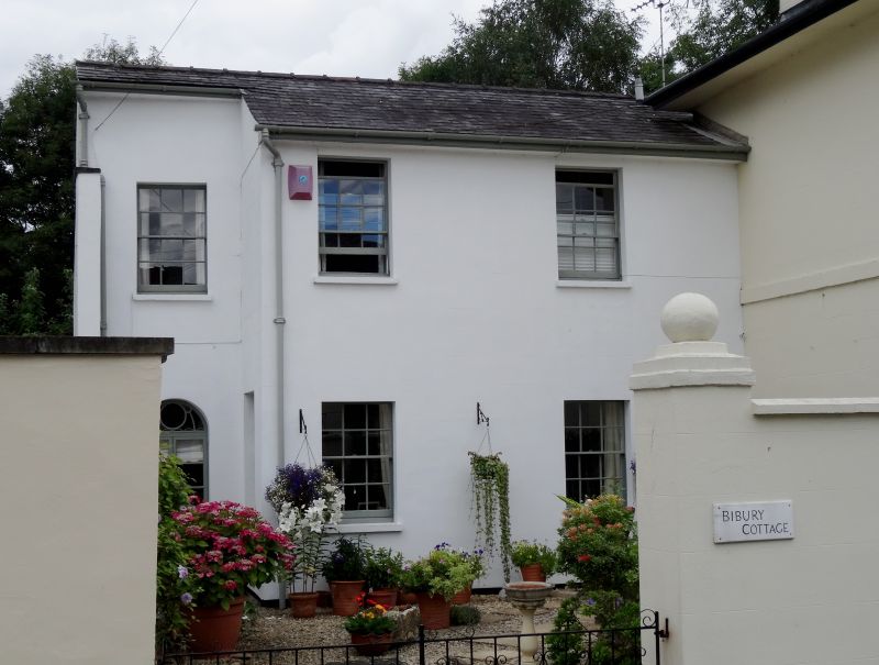
Villa, now 2 dwellings. c1820-34, shown on Merrett's Map of
1834. stucco over brick with hipped slate roof, stucco end
stacks with cornices to main range.
EXTERIOR: 2 storeys, 3 bays, with 2-storey, 3
first-floor-window range set back to left and range to rear at
right. Main range: 3:1:3 windows, the outer bays are canted to
full height and with projecting range to ground floor.
First-floor band. 6/6 sashes and blind openings throughout.
Central entrance: 6 fielded-panel door with overlight.
Projecting range has low parapet with copings. Range at left:
stepped. Mainly 6/6 sashes; to left, at ground floor a former
entrance now with casement window, retains fanlight with
batwing and circle type glazing bars.
INTERIOR: noted as retaining original plasterwork and joinery
including panelled shutters.
(Merrett HS: Plan of the Town of Cheltenham: 1834-).
Listing NGR: SO9535921903
External links are from the relevant listing authority and, where applicable, Wikidata. Wikidata IDs may be related buildings as well as this specific building. If you want to add or update a link, you will need to do so by editing the Wikidata entry.


Other nearby listed buildings
