Approximate Location Map
Large Map »
Latitude: 51.9022 / 51°54'8"N
Longitude: -2.0792 / 2°4'45"W
OS Eastings: 394645
OS Northings: 222634
OS Grid: SO946226
Mapcode National: GBR 2M4.P52
Mapcode Global: VH947.XG53
Plus Code: 9C3VWW2C+V8
Entry Name: 3 and 4, St Georges Square
Listing Date: 5 May 1972
Last Amended: 26 November 1998
Grade: II
Source: Historic England
Source ID: 1387854
English Heritage Legacy ID: 475846
ID on this website: 101387854
Location: Cheltenham, Gloucestershire, GL50
County: Gloucestershire
District: Cheltenham
Electoral Ward/Division: Lansdown
Parish: Non Civil Parish
Built-Up Area: Cheltenham
Traditional County: Gloucestershire
Lieutenancy Area (Ceremonial County): Gloucestershire
Church of England Parish: Cheltenham, St Mary with St Matthew
Church of England Diocese: Gloucester
Tagged with: Building
CHELTENHAM
SO9422NE ST GEORGE'S SQUARE
630-1/9/826 (South side)
05/05/72 Nos.3 AND 4
(Formerly Listed as:
ST GEORGE'S SQUARE
(South side)
Nos.3, 4 AND 5)
GV II
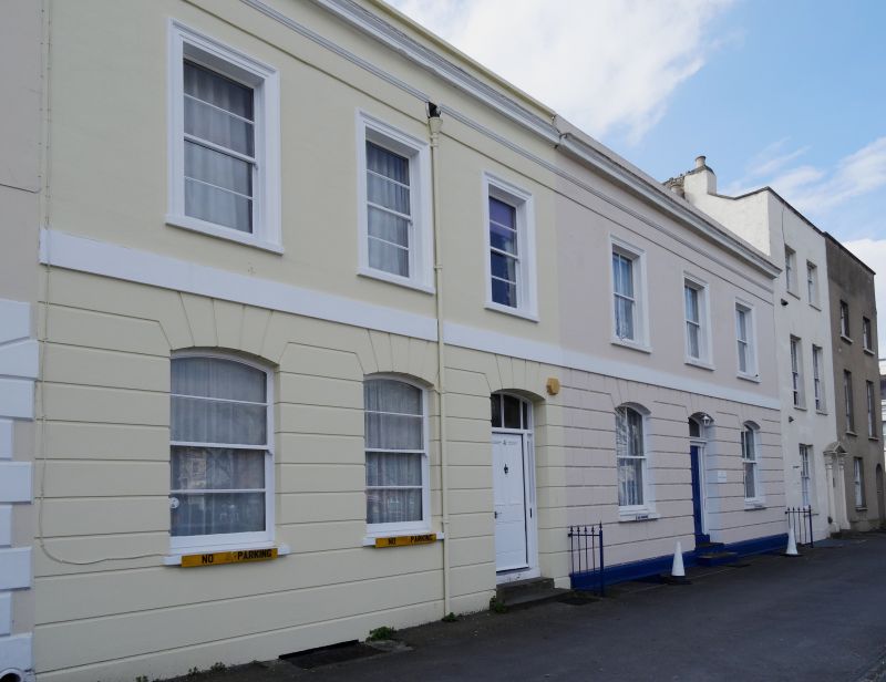
Pair of terraced houses. c1806 with later additions and
alterations. Numbered right to left, described left to right.
Stucco over brick with concealed roof.
EXTERIOR: 2 storeys with attics, 6 first-floor windows (3:3).
Stucco detailing includes ground-floor horizontal rustication,
to left and rustication to right, drawn into voussoirs over
elliptically-arched openings; first-floor band; first-floor
windows have tooled architraves; crowning entablature with
blocking course and copings. 6/6 sashes where original, those
to ground floor have cambered heads. Entrances to right and
centre: 3- and 4-panel doors with sidelights and
cambered-arched overlights. Attic dormers to rear.
INTERIOR: No.3 has central hall with dogleg staircase with
stick balusters with scrolled panels of iron ornament and
wreathed handrail.
HISTORICAL NOTE: St George's Square was laid out from 1806
onwards on a field called Rack Close.
(Sampson A and Blake S: A Cheltenham Companion: Cheltenham:
1993-: 112).
Listing NGR: SO9464222637
External links are from the relevant listing authority and, where applicable, Wikidata. Wikidata IDs may be related buildings as well as this specific building. If you want to add or update a link, you will need to do so by editing the Wikidata entry.


Other nearby listed buildings
