Approximate Location Map
Large Map »
Latitude: 51.891 / 51°53'27"N
Longitude: -2.0858 / 2°5'8"W
OS Eastings: 394193
OS Northings: 221390
OS Grid: SO941213
Mapcode National: GBR 2MB.FHF
Mapcode Global: VH947.SQPP
Plus Code: 9C3VVWR7+CM
Entry Name: Number 10 and Attached Railings
Listing Date: 12 March 1955
Grade: II
Source: Historic England
Source ID: 1388155
English Heritage Legacy ID: 476153
ID on this website: 101388155
Location: Tivoli, Cheltenham, Gloucestershire, GL50
County: Gloucestershire
District: Cheltenham
Electoral Ward/Division: Park
Parish: Non Civil Parish
Built-Up Area: Cheltenham
Traditional County: Gloucestershire
Lieutenancy Area (Ceremonial County): Gloucestershire
Church of England Parish: Leckhampton St Philip and St James
Church of England Diocese: Gloucester
Tagged with: Building
CHELTENHAM
SO9421SW TIVOLI ROAD
630-1/22/958 (East side)
12/03/55 No.10
and attached railings
GV II
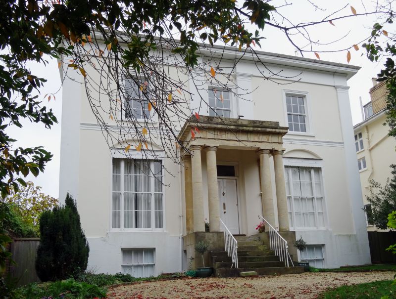
Villa and attached railings. c1834-40. Stucco over brick with
ashlar porch, hipped slate roof and left end stack; iron
railings.
EXTERIOR: 2 storeys on basement, 3 first-floor windows.
Central first-floor window win slight recess forming wide
outer breakforwards. Stucco detailing includes Doric pilasters
to breakforwards (those at centre are from first floor),
crowning frieze; moulded first-floor band; ground-floor
windows have elliptically-arched recesses over and first-floor
windows are in tooled architraves. Wide eaves. First floor has
6/6 sashes, ground floor has tall 6/6 between 2/2 sashes,
basement has 3/6 sashes; all in plain reveals, those to first
floor with sills. Flight of 7 steps to central entrance in
Doric portico with paired columns and triglyphs and metopes to
frieze, panelled door with overlight.
INTERIOR: not inspected.
SUBSIDIARY FEATURES: stick railings to sides of steps.
HISTORICAL NOTE: houses along Tivoli Road (originally known as
Tivoli) are shown as laid out on Merrett's Map of 1834.
Listing NGR: SO9419921390
External links are from the relevant listing authority and, where applicable, Wikidata. Wikidata IDs may be related buildings as well as this specific building. If you want to add or update a link, you will need to do so by editing the Wikidata entry.


Other nearby listed buildings
