Approximate Location Map
Large Map »
Latitude: 51.9007 / 51°54'2"N
Longitude: -2.0728 / 2°4'22"W
OS Eastings: 395086
OS Northings: 222459
OS Grid: SO950224
Mapcode National: GBR 2M4.YJX
Mapcode Global: VHB1Q.1H19
Plus Code: 9C3VWW2G+7V
Entry Name: 14, 16 and 18, Winchcombe Street
Listing Date: 14 December 1983
Grade: II
Source: Historic England
Source ID: 1388220
English Heritage Legacy ID: 476218
ID on this website: 101388220
Location: Cheltenham, Gloucestershire, GL52
County: Gloucestershire
District: Cheltenham
Electoral Ward/Division: All Saints
Parish: Non Civil Parish
Built-Up Area: Cheltenham
Traditional County: Gloucestershire
Lieutenancy Area (Ceremonial County): Gloucestershire
Church of England Parish: Cheltenham Holy Trinity
Church of England Diocese: Gloucester
Tagged with: Building
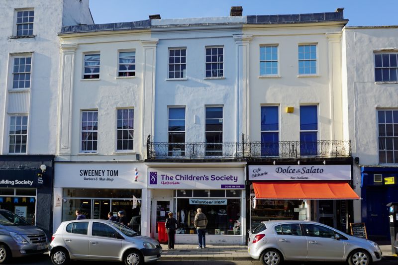
CHELTENHAM
SO9522SW WINCHCOMBE STREET
630-1/14/1007 (West side)
14/12/83 Nos.14, 16 AND 18
II
Terrace of 3 houses, now shops with offices over. c1820 with
c1970s ground-floor shop fronts. Stucco over brick with
concealed roof and brick party-wall stacks and wrought-iron
balconies.
EXTERIOR: 3 storeys, 6 first-floor windows (2 per house).
Stucco detailing includes Doric pilasters through first and
second floors with sunk panels, to ends and party-walls
surmounted by frieze and cornice with blocking course. 6/6 and
2/2 horizontal-pane sashes, all in plain reveals and with
sills; windows to first floor are taller. Ground floor has
glazed shop fronts, those to centre and left are canted in to
entrances, all of which are glazed doors.
INTERIOR: not inspected.
SUBSIDIARY FEATURES: continuous first-floor balconies to
centre and right with elongated scroll motif and lattice
frieze and with panels of lyre pattern and circular flowers.
HISTORICAL NOTE: may be shown on the Post Office Map of 1820.
(Chatwin A: Cheltenham's Ornamental Ironwork: Cheltenham:
1975-1984: 26; The Post Office Map: 1820-).
Listing NGR: SO9507922458
External links are from the relevant listing authority and, where applicable, Wikidata. Wikidata IDs may be related buildings as well as this specific building. If you want to add or update a link, you will need to do so by editing the Wikidata entry.


Other nearby listed buildings
