Approximate Location Map
Large Map »
Latitude: 53.2369 / 53°14'12"N
Longitude: -0.5369 / 0°32'13"W
OS Eastings: 497744
OS Northings: 372095
OS Grid: SK977720
Mapcode National: GBR FMQ.32M
Mapcode Global: WHGHZ.QWHX
Plus Code: 9C5X6FP7+Q6
Entry Name: Close Wall Adjoining Numbers 4 and 10 and 12 (Numbers 10 and 12 Not Included) Number 5 and Adjoining Sections of the Close Wall
Listing Date: 2 October 1969
Grade: II
Source: Historic England
Source ID: 1388511
English Heritage Legacy ID: 485956
ID on this website: 101388511
Location: Lincoln, Lincolnshire, LN2
County: Lincolnshire
District: Lincoln
Electoral Ward/Division: Minster
Parish: Non Civil Parish
Built-Up Area: Lincoln
Traditional County: Lincolnshire
Lieutenancy Area (Ceremonial County): Lincolnshire
Church of England Parish: Lincoln, St Mary Magdalene with St Paul in the Bail and St Michael on the Mount
Church of England Diocese: Lincoln
Tagged with: Wall
LINCOLN
SK9772SE EAST BIGHT
1941-1/7/90 (South side)
02/10/69 No.5
and adjoining sections of the Close
wall
GV II
Includes: Close Wall adjoining Nos.4, 10 and 12 (Nos.10 and 12
not included) JAMES STREET.
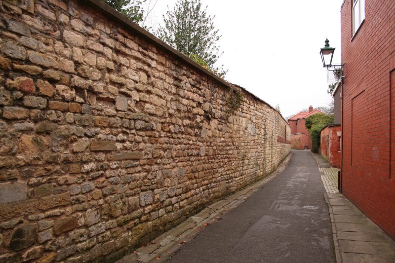
Stables, now a house, and adjoining sections of the Cathedral
Close wall. Early C14 and early C19, with C20 additions and
alterations. Coursed and squared stone with stone dressings
and pantile roofs, with single coped ridge and gable stacks.
Pantile and concrete copings to the wall.
House, 2 storeys, has to south a door flanked by single C20
windows all with round heads, and to left a basket arched
carriage opening with C20 glazed screen and door. To left
again, a lower single bay with an Early English style double
lancet. Beyond, single storey outbuildings, C19 and C20.
To the south, a section of wall approx. 75m long.
To east, bordering East Bight to the south, a section of wall
approx. 90m long, with a moulded elliptical carriage arch with
a pair of doors at the west end. At the east end, a rounded
corner. Beyond, bordering East Bight to the west, a section of
wall approx. 150m long.
This section of the Close wall has been pierced and patched,
but is substantially original.
(Buildings of England : Lincolnshire: Pevsner N: Lincolnshire:
London: 1989-: 483-484).
LINCOLN
SK9772SE JAMES STREET
1941-1/7/90 Close Wall adjoining Nos.4, 10 and
02/10/69 12 (Nos.10 and 12 not included)
GV II
Listing NGR: SK9774472095
External links are from the relevant listing authority and, where applicable, Wikidata. Wikidata IDs may be related buildings as well as this specific building. If you want to add or update a link, you will need to do so by editing the Wikidata entry.


Other nearby listed buildings
