Approximate Location Map
Large Map »
Latitude: 53.2273 / 53°13'38"N
Longitude: -0.541 / 0°32'27"W
OS Eastings: 497497
OS Northings: 371020
OS Grid: SK974710
Mapcode National: GBR FMQ.N1M
Mapcode Global: WHGJ5.N4LQ
Plus Code: 9C5X6FG5+WJ
Entry Name: 320 High Street
Listing Date: 8 July 1991
Last Amended: 13 June 2022
Grade: II
Source: Historic England
Source ID: 1388591
English Heritage Legacy ID: 486036
ID on this website: 101388591
Location: Lincoln, Lincolnshire, LN5
County: Lincolnshire
District: Lincoln
Electoral Ward/Division: Park
Parish: Non Civil Parish
Built-Up Area: Lincoln
Traditional County: Lincolnshire
Lieutenancy Area (Ceremonial County): Lincolnshire
Church of England Parish: Lincoln St Mary-le-Wigford
Church of England Diocese: Lincoln
Tagged with: Building
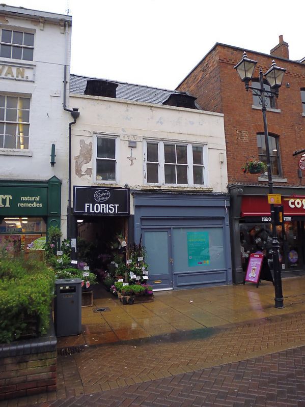
A small commercial building thought to date from the late C18.
A small commercial building thought to date from the late C18.
MATERIALS: the building’s principal, western frontage is rendered to the first floor under a slate roof covering, and contains a timber shopfront on the ground floor, with a lead roof covering. The rear range is of red brick with a plain tiled roof.
PLAN: the building stands on the east side of High Street, facing west.
EXTERIOR: the building is of two storeys across two bays, the southern bay being wider than the northern. The northern bay of the ground floor contains a passage giving access to the rear ranges of the building and the adjacent property at 319 High Street.
On the first floor, the southern bay contains a tripartite sash window, while the northern bay contains a two-pane sash. A wide plat band runs across the elevation intersecting with the window heads, above which is a rendered parapet with lead coping. The parapet conceals the lower part of the pitched roof, which slopes towards the High Street and contains two dormers, both of which contain metal grilles.
A long, rear range extends eastward from the principal range fronting the High Street. It is of two storeys in red brick with a pitched, plain-tiled roof.
Listing NGR: SK9749771020
Lincoln High Street is part of the major Roman road, Ermine Street, linking London to York. It has served as the principal route into the city from the south since the first century when a legionary fortress was established on what is now ‘Uphill’ Lincoln (the vicinity of the cathedral and castle). The fortress was later transformed into a civilian settlement, taking the name Colonia Lindum, from which its modern name is derived. The Roman town gradually expanded south along Ermine Street beyond the River Witham. This development pattern was largely re-established after the Vikings resettled the city during the C9. By the time of the Norman Conquest, both sides of Ermine Street appear to have been developed for some distance south of the river, but as late as the C18, development to the east and west of the High Street was mostly limited to the areas of the castle and cathedral in ‘Uphill’ Lincoln and along the riverfront in ‘Downhill’ Lincoln.
The land south of the River Witham witnessed considerable industrial and commercial growth during the late C18 and C19. The land to the east and west of the High Street was transformed into a network of workshops, factories and yards, a trend reinforced by the arrival of the Midland Railway in 1846, followed by the Great Northern Railway in 1848, which transformed a large swathe of the area into a complex of railway buildings, storehouses and sidings. The High Street witnessed gradual redevelopment throughout this period, creating the largely C19 streetscape seen today, although a significant number of pre-industrial buildings have survived, often hidden behind later facades.
The current building at 320 High Street appears to have been built during the mid- to late C18, possibly as a shophouse fronting the High Street. Very little is known about the building’s early history. Archaeological investigations carried out at 320 High Street in 1997 revealed medieval finds dating from between the C11 and C16, including an oven base and separate hearth base. The finds suggest that a building had existed on the site of number 320 for centuries prior to the construction of the existing building. The existing building appears to have been refronted during the early C19. It appears to be depicted on Padley’s map of 1842, while the 1888 OS Town Plan of Lincoln depicts the building’s rear range extending further to the east than at present. This rear range was curtailed sometime between the 1930s and 1960s to reach its current size. During the 1970s, the building was the office of an insurance company and had a timber and glazed shopfront bearing a Classical cornice. The shopfront was replaced during the late C20 century with the existing timber shopfront, while the two dormers in the western slope of the roof were converted to ventilation grilles.
Legacy Record – This information may be included in the List Entry Details.
External links are from the relevant listing authority and, where applicable, Wikidata. Wikidata IDs may be related buildings as well as this specific building. If you want to add or update a link, you will need to do so by editing the Wikidata entry.


Other nearby listed buildings
