Approximate Location Map
Large Map »
Latitude: 52.4891 / 52°29'20"N
Longitude: -1.9099 / 1°54'35"W
OS Eastings: 406216
OS Northings: 287914
OS Grid: SP062879
Mapcode National: GBR 5Y5.6L
Mapcode Global: VH9YW.VP5Q
Plus Code: 9C4WF3QR+J3
Entry Name: 48-56, Branston Street
Listing Date: 29 August 2001
Grade: II
Source: Historic England
Source ID: 1389402
English Heritage Legacy ID: 488061
ID on this website: 101389402
Location: Hockley, Birmingham, West Midlands, B18
County: Birmingham
Parish: Non Civil Parish
Built-Up Area: Birmingham
Traditional County: Warwickshire
Lieutenancy Area (Ceremonial County): West Midlands
Church of England Parish: Birmingham St Paul
Church of England Diocese: Birmingham
Tagged with: Building
BIRMINGHAM
997/0/10275 BRANSTON STREET
29.8.01 48-56
II
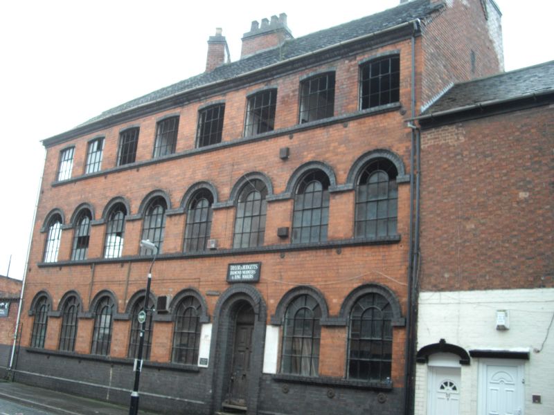
Manufactory, empty at time of inspection (August 2000) . c. 1870, with minor late C20 alterations. Red brick with blue brick detailing and a plain tile roof, hipped at the south-east end. PLAN. Irregular, triangular building, on a wedge-shaped plot bounded by Branston Street and the railway cutting for the line which passes under Branston Street.
EXTERIOR: Front elevation of 3 storeys and 8 bays, rising from a chamfered blue brick plinth. Ground and first floor windows with semi-circular arched heads, with linked hood moulds in blue brick forming a continuous band. Ground floor windows overboarded at time of inspection. Upper floor openings with shallow segmental arched heads. C20 replacement frames for former cast-iron multi-paned frames which remain in situ in south-west end and rear elevations. Main entrance to bay 6, with stepped semi-circular arched doorway with blue brick surround and 6-panel door. Blue brick eaves band . Rear elevation with cast-iron, multi-pane window frames beneath brick segmental arched heads. C20 timber fire escape. Irregularly- placed chimney stacks, with end wall stacks to both slopes to the north-east gable, a clustered ridge stack, a stack parallel to the ridge, and a tranverse stack. These stacks served at least 16 flues, and their positions were made necessary by the buildings' eccentric plan form.
INTERIOR: not inspected.
HISTORY: The manufactory, known as the Branston Street Works is shown on the 1886-7 Ordnance Survey map in its present form. The 1886 Trade Directory lists 12 craftsmen , including jewellers, engravers and chasers occupying the site, ( the form of which, unusually, precluded the provision of a vehicle entrance ) suggesting that the works were designed for multi-occupancy from the outset..
A late C19 purpose-built manufactory, designed to provide workshop facilities for independent craftsmen. The use of such a very restricted site demonstrates the demand for industrial workshop space, and the value of vacant land , however limited,in the late C19 in this industrial quarter of Birmingham, now recognised as being of international significance.
External links are from the relevant listing authority and, where applicable, Wikidata. Wikidata IDs may be related buildings as well as this specific building. If you want to add or update a link, you will need to do so by editing the Wikidata entry.


Other nearby listed buildings
