Approximate Location Map
Large Map »
Latitude: 52.4855 / 52°29'7"N
Longitude: -1.9116 / 1°54'41"W
OS Eastings: 406096
OS Northings: 287514
OS Grid: SP060875
Mapcode National: GBR 5X6.SW
Mapcode Global: VH9YW.TS7G
Plus Code: 9C4WF3PQ+68
Entry Name: 22, Frederick Street
Listing Date: 9 October 2001
Grade: II
Source: Historic England
Source ID: 1389454
English Heritage Legacy ID: 488115
ID on this website: 101389454
Location: Brookfields, Birmingham, West Midlands, B1
County: Birmingham
Parish: Non Civil Parish
Built-Up Area: Birmingham
Traditional County: Warwickshire
Lieutenancy Area (Ceremonial County): West Midlands
Church of England Parish: Birmingham St Paul
Church of England Diocese: Birmingham
Tagged with: Building
BIRMINGHAM
997/0/10282 FREDERICK STREET
09-OCT-01 22
II
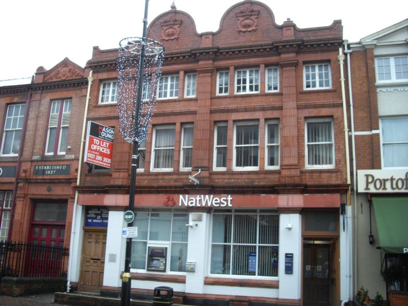
Bank, formerly manufactory. Dated 1901, with late C20 alterations. Terracotta decorative facade with slated hipped roof covering.
PLAN: L-shaped plan with deep double pile frontage range and storeyed workshop range to rear on north side of narrow yard.
EXTERIOR: Elaborately detailed 3 storey frontage range of 4 bays, with windows grouped 1:3:3:1 to first and second floors, Ground floor with doorways to outer bays, each with a wide, 9- panel door below a rectangular fanlight. 2, C20 6-pane shop windows within rendered surround below wide storey band. Above , fluted tapered pilsters flank and separate tripartite sash windows to first floor and shallow glazing bar casements to second floor. Moulded string course between pilasters . Deep dentilled cornice below parapet with twin Dutch gables with decorative date plaques and finials. Rear elevation with attached former workshop range of 2 storeys and 6 bays, confirming former usage as manufactory.
INTERIOR: The ground floor of the frontage range has been remodelled to form a banking hall, which itself retains some early C19 fittings.
HISTORY: The site is shown on the 1889 Ordnance Survey, where it is identified as a jewellery works. It is depicted as an U-shaped complex with a narrow rear yard bounded by workshops to the north and east. The entrance to the yard is shown on the right-hand side of the street elevation, where a doorway exists at the present time. The northern workshop range position conforms with that of the present day building.
Forms a group with No. 23 Frederick Street .
A late C19 manufactory, remodelled in 1901, and now used as a bank, but retaining a fine terracotta-faced street elevation and attached former rear workshops. It forms part of a significant grouping of manufactories in the heart of an industrial district now considered to be of international significance.
External links are from the relevant listing authority and, where applicable, Wikidata. Wikidata IDs may be related buildings as well as this specific building. If you want to add or update a link, you will need to do so by editing the Wikidata entry.


Other nearby listed buildings
