Approximate Location Map
Large Map »
Latitude: 52.1887 / 52°11'19"N
Longitude: -2.2192 / 2°13'8"W
OS Eastings: 385113
OS Northings: 254515
OS Grid: SO851545
Mapcode National: GBR 1G4.PS0
Mapcode Global: VH92T.H850
Plus Code: 9C4V5QQJ+F8
Entry Name: 26, College Street
Listing Date: 5 April 1971
Grade: II
Source: Historic England
Source ID: 1389724
English Heritage Legacy ID: 488675
ID on this website: 101389724
Location: Diglis, Worcester, Worcestershire, WR1
County: Worcestershire
District: Worcester
Electoral Ward/Division: Cathedral
Parish: Non Civil Parish
Built-Up Area: Worcester
Traditional County: Worcestershire
Lieutenancy Area (Ceremonial County): Worcestershire
Church of England Parish: Worcester St Nicholas and All Saints
Church of England Diocese: Worcester
Tagged with: Building
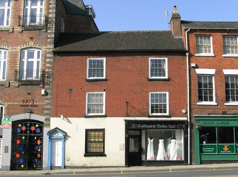
WORCESTER
SO8554NW COLLEGE STREET
620-1/17/183 (West side)
05/04/71 No.26
GV II
House, now shop. c1808-32 with later additions and alterations
including shop front Late C19. Pinkish-red brick in Flemish
bond, painted to ground floor, with flat arches of red gauged
brick; renewed stone sills; plain tile roof and right end
brick stack. 3 storeys, 3 first-floor windows. First floor has
renewed 1/1 sashes, second floor has 8/8 flush sashes, all
with renewed sills and lat arches. Ground floor has renewed
flush plate-glass window with sill and flat arch; entrance at
left a board door in renewed doorcase retaining open pediment;
off-centre right entrance incorporated into shop front,
plate-glass door with overlight, glazed window on apron,
canted in towards door, fascia, end pilasters with moulded
corbels and cornice.
INTERIOR: not inspected.
HISTORICAL NOTE: apparently not shown on Young's Map c1808 but
shown on Clements's Map of 1832. Nos. 26-30 (cons) College
Street (qv) form a good group and provide a visual approach to
the Cathedral of Christ and St Mary (qv).
(Young G: Map of Worcester: London: 1808-; Clements J: A Plan
of the City and Environs of Worcester: Worcester: 1832-).
External links are from the relevant listing authority and, where applicable, Wikidata. Wikidata IDs may be related buildings as well as this specific building. If you want to add or update a link, you will need to do so by editing the Wikidata entry.


Other nearby listed buildings
