Approximate Location Map
Large Map »
Latitude: 52.1967 / 52°11'47"N
Longitude: -2.2231 / 2°13'23"W
OS Eastings: 384846
OS Northings: 255404
OS Grid: SO848554
Mapcode National: GBR 1G4.8RC
Mapcode Global: VH92T.F12V
Plus Code: 9C4V5QWG+MQ
Entry Name: Restdale House
Listing Date: 22 May 1954
Last Amended: 5 July 2001
Grade: II
Source: Historic England
Source ID: 1389810
English Heritage Legacy ID: 488761
ID on this website: 101389810
Location: Worcester, Worcestershire, WR1
County: Worcestershire
District: Worcester
Electoral Ward/Division: Cathedral
Parish: Non Civil Parish
Built-Up Area: Worcester
Traditional County: Worcestershire
Lieutenancy Area (Ceremonial County): Worcestershire
Church of England Parish: Worcester St Nicholas and All Saints
Church of England Diocese: Worcester
Tagged with: House
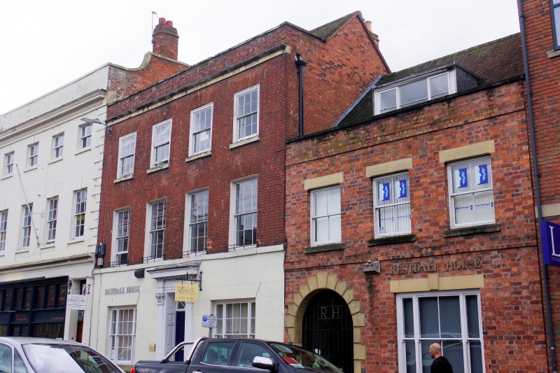
WORCESTER
SO8455SE FRIAR STREET
620-1/12/252 (West side)
22/05/54 No.33
Restdale House
(Formerly Listed as:
FRIAR STREET
(West side)
No.33)
GV II
House. Late C18 with later alterations. Pinkish-red brick in
Flemish bond with stucco to ground floor, scored in imitation
of ashlar; stone sills, bands, copings and architrave; plain
tile roof and brick stacks to rear with pots. 3 storeys, 4
first-floor windows. First floor has 6/6 sashes in plain
reveals and with continuous sill band; second floor has 6/6
sashes in near-flush frames with sills; all wit flat arches of
gauged brick. Ground floor: chamfered plinth; central
entrance, 3 roll-edged steps to 6-raised-and-fielded-panel
door with overlight with radial glazing bars in doorcase with
fluted composite pilasters, dentil entablature and hood.
Ground floor has 2 tripartite windows with 6/6 between 2/2
sashes in plain reveals and with sills and flat, stuccoed
arches.
INTERIOR: not inspected.
HISTORICAL NOTE: during the C18 Foregate Street was known as
'the mall' and Tymbs' Worcester Guide of 1802 notes, 'the
Foregate Street itself, by being well paved and sufficiently
broad to admit a full circulation of air seems to be generally
resorted to as a fashionable promenade.'
The Shire Hall, Statue of Queen Victoria, City Museum and
Library, and Nos 15, 19, 22, 23, 24, 28, nos 33-46
(consecutive) and No.49, Foregate Street (qqv) form a
significant group.
(Worcestershire Historical Society Occasional Papers:
Whitehead D: Urban Renewal and Suburban Growth: The Shaping of
Georgian Worcester: 1989-: 12; Tymbs: Worcester Guide:
Worcester: 1802-: 60).
External links are from the relevant listing authority and, where applicable, Wikidata. Wikidata IDs may be related buildings as well as this specific building. If you want to add or update a link, you will need to do so by editing the Wikidata entry.


Other nearby listed buildings
