Approximate Location Map
Large Map »
Latitude: 52.0586 / 52°3'30"N
Longitude: 1.1379 / 1°8'16"E
OS Eastings: 615215
OS Northings: 244671
OS Grid: TM152446
Mapcode National: GBR TMP.SLS
Mapcode Global: VHLBS.NJY7
Plus Code: 9F43345Q+C5
Entry Name: 121, London Road
Listing Date: 19 April 2004
Grade: II
Source: Historic England
Source ID: 1390635
English Heritage Legacy ID: 490862
ID on this website: 101390635
Location: Ipswich, Suffolk, IP1
County: Suffolk
District: Ipswich
Electoral Ward/Division: Gipping
Parish: Non Civil Parish
Built-Up Area: Ipswich
Traditional County: Suffolk
Lieutenancy Area (Ceremonial County): Suffolk
Church of England Parish: St Matthew Triangle and All Saints
Church of England Diocese: St.Edmundsbury and Ipswich
Tagged with: Building
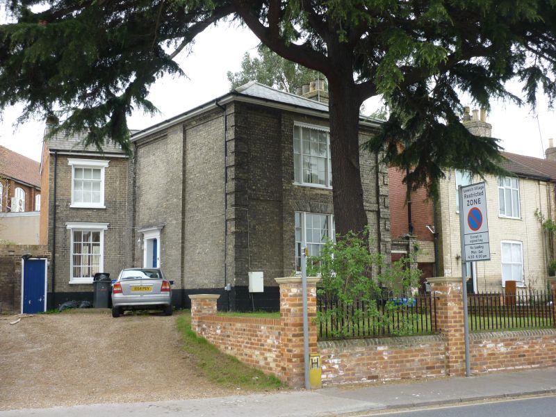
642/0/10097 LONDON ROAD
19-APR-04 Mile End
121
II
House. c.1820. Gault brick with red brick to rear walls and slate hipped roof to front range with C20 tile to small rear range. Right side stack. Late Classical style. 2 storeys and basement. Front has a tripartite sash, 2/2:6/6:2/2 panes, on both floors with crown glass to upper. Windows are set in a raised panel and there are rusticated quoins. The side walls are panelled. Original 5-panel door to left side. Small rear range has a sash on both floors with cornice hoodmould: 3/6 over 6/6. Mostly sashes to rear which are either 3/3 or 2/2, and a door to the semi-basement.
INTERIOR. The little altered interior includes a small open-well staircase with mahogany curving and wreathed handrail and stick balusters with fluted bottom newel. Reeded architraves with corner roundels to many doorways. Front reception room has window shutters and side arches to the chimney breast with another opposite. Cornices and architraves. Original fireplaces in 2 upper rooms have cast-iron grates and there is a later C19 range in the rear main basement room. Further extensive semi-basements and cellars with stone floors.
HISTORY. This area, known as 'Mile End', was laid out in the early C19 as a small isolated development of 16 houses to the main London road, and the house is marked on the first available map which is of 1847.
This is a little-altered small Regency villa which retains original fenestration and many finely detailed interor features.
External links are from the relevant listing authority and, where applicable, Wikidata. Wikidata IDs may be related buildings as well as this specific building. If you want to add or update a link, you will need to do so by editing the Wikidata entry.


Other nearby listed buildings
