Approximate Location Map
Large Map »
Latitude: 52.487 / 52°29'13"N
Longitude: -1.9141 / 1°54'50"W
OS Eastings: 405928
OS Northings: 287676
OS Grid: SP059876
Mapcode National: GBR 5X6.7C
Mapcode Global: VH9YW.RRYC
Plus Code: 9C4WF3PP+Q9
Entry Name: 67-69, Warstone Lane
Listing Date: 29 April 2004
Grade: II
Source: Historic England
Source ID: 1392831
English Heritage Legacy ID: 505872
ID on this website: 101392831
Location: Brookfields, Birmingham, West Midlands, B18
County: Birmingham
Parish: Non Civil Parish
Built-Up Area: Birmingham
Traditional County: Warwickshire
Lieutenancy Area (Ceremonial County): West Midlands
Church of England Parish: Birmingham St Paul
Church of England Diocese: Birmingham
Tagged with: Building
BIRMINGHAM
997/0/10258 WARSTONE LANE
29-APR-04 67-69
GV II
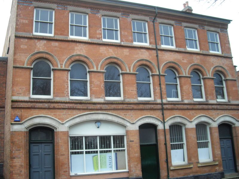
Manufactory. c. 1880 with late C20 alterations. Red brick with painted stone dressings and blue brick detailing . Gable and ridge chimneys with a slate roof covering.
PLAN: Rectangular street frontage range, with central passage entrance to rear workshops.
EXTERIOR: Near-symmetrical 7 bay frontage range of 3 storeys on a shallow blue brick plinth, with 3 doorways, 2 to outer bays and centre doorway to passage. Outer doorways with moulded surrounds and shallow segmental arched heads, double doors and arch-headed overlights. Plainer and narrower centre doorway with deep barred overlight.. To the left, a wide segmental arch above a display window with a transomed 4-light C20 frame. To the right, a pair of tall, arch-headed windows with undivided sash frames. The arched heads to door and window openings are linked within an undulating lintel band, with continuous drip mould above. First floor moulded storey band, with painted cill band above, and an arcade of 7 semi-circular arch-headed openings with undivided sash frames. Imposts, cills and arched heads are all painted. Upper floor windows have painted flat lintels set within bands of blue brick, and margin-glazed sashes set upon a painted cill band.
HISTORY: The complex first appears on the 1889 Ordnance survey map and at that date is made up 2 separate parts, The Warstone Buildings to the east and The Lion Electro-plating Works to the west. The Warstone Buildings accommodated 12 separate occupants in 1886, the rear yard being shown with a central dividing wall , suggesting that the complex was specifically designed for shared occupancy. The 1886 trade directory identifies the Lion Works as the premises of Frederick Whitehouse, manufacturer of cutlery and electro-plated goods.
Forms a group with Nos. 62-64 Warstone Lane (q.v.)
A late C19 manufactory designed for shared occupancy, its plan form and architectural detailing characteristic of the specialist industrial premises developed in a distinctive manufacturing quarter of Birmingham, now recognised
as being of international significance.
External links are from the relevant listing authority and, where applicable, Wikidata. Wikidata IDs may be related buildings as well as this specific building. If you want to add or update a link, you will need to do so by editing the Wikidata entry.


Other nearby listed buildings
