Approximate Location Map
Large Map »
Latitude: 51.3798 / 51°22'47"N
Longitude: -2.3613 / 2°21'40"W
OS Eastings: 374950
OS Northings: 164594
OS Grid: ST749645
Mapcode National: GBR 0QH.HTG
Mapcode Global: VH96M.1L02
Plus Code: 9C3V9JHQ+WF
Entry Name: 45, St James's Parade
Listing Date: 12 June 1950
Last Amended: 15 October 2010
Grade: II
Source: Historic England
Source ID: 1394838
English Heritage Legacy ID: 510245
ID on this website: 101394838
Location: Bath, Bath and North East Somerset, Somerset, BA1
County: Bath and North East Somerset
Parish: Non Civil Parish
Built-Up Area: Bath
Traditional County: Somerset
Lieutenancy Area (Ceremonial County): Somerset
Tagged with: Building
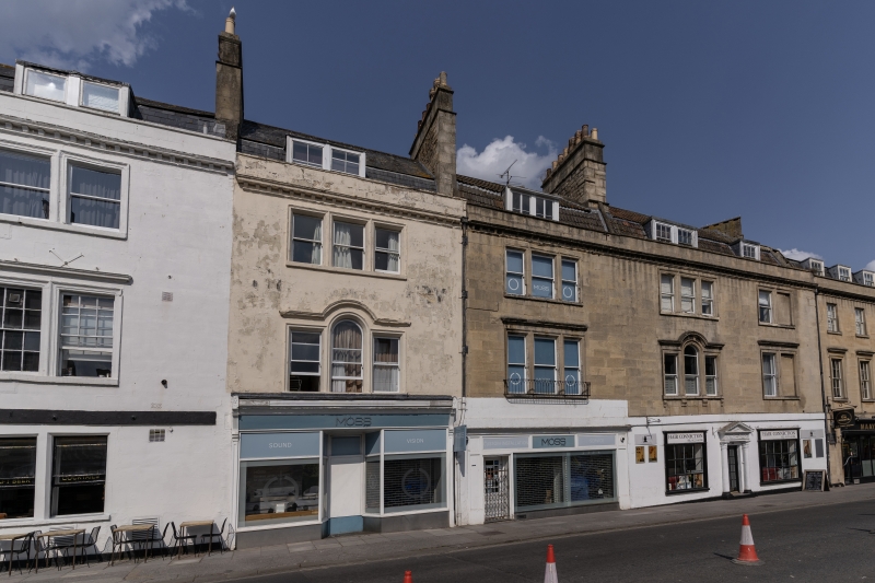
ST JAMES'S PARADE
656-1/40/2463 (North East side)
No.45
(Formerly Listed as: ST JAMES'S PARADE
(North East side) Nos 31-46 (consec)
& No.47 (Talbot Public House))
12/06/50
GV II
House in terrace, with shop. c1785, probably by John Palmer.
MATERIALS: Limestone ashlar, double Roman tile roof.
PLAN: Three storeys, attic and basement, single window, paired casement dormer above triple plain sashes in moulded architraves, with cornice drip at first floor, also has balconette. Full width C20 shopfront, with recessed doorway, left. Plain platband above ground floor, modillion cornice with blocking course and parapet, large stack to coped party division in mansard roof, right, shared with No.44 (qv), `stitched' joint in ashlar to right, suggesting that property, although part of overall development of terrace, followed in sequence. Rear, in rubble, has twelve-pane sashes in splayed surrounds.
INTERIOR: Not inspected. Street was laid out in 1768, but this range part of later development.
HISTORY: St James's Parade, originally Thomas Street, was the centrepiece of a development from 1765 onwards by Richard Jones, Thomas Jelly and Henry Fisher who were granted liberty in September 1765 to 'pull down the Boro' walls next to the Ambry gardens in order to build new houses there'. The street was closed off with bollards at each end, and the houses fronted a broad paved walk in place of the road. The elevations, attributed to Thomas Jelly and John Palmer, show the influence of John Wood the Younger's work elsewhere, as in Rivers Street. The houses were mainly built in c.1768. Following bomb damage in the area, extensive clearance and redevelopment has taken place. St James's Parade, after an uncertain period, was reprieved. This particular house was a rather later development in this 1760s street
Listing NGR: ST7495064594
External links are from the relevant listing authority and, where applicable, Wikidata. Wikidata IDs may be related buildings as well as this specific building. If you want to add or update a link, you will need to do so by editing the Wikidata entry.


Other nearby listed buildings
