Approximate Location Map
Large Map »
Latitude: 51.3822 / 51°22'56"N
Longitude: -2.3619 / 2°21'42"W
OS Eastings: 374909
OS Northings: 164859
OS Grid: ST749648
Mapcode National: GBR 0QH.9PB
Mapcode Global: VH96M.0JQ7
Plus Code: 9C3V9JJQ+V6
Entry Name: Blue Coat House
Listing Date: 5 August 1975
Last Amended: 15 October 2010
Grade: II
Source: Historic England
Source ID: 1394901
English Heritage Legacy ID: 510311
ID on this website: 101394901
Location: Bath, Bath and North East Somerset, Somerset, BA1
County: Bath and North East Somerset
Parish: Non Civil Parish
Built-Up Area: Bath
Traditional County: Somerset
Lieutenancy Area (Ceremonial County): Somerset
Tagged with: House
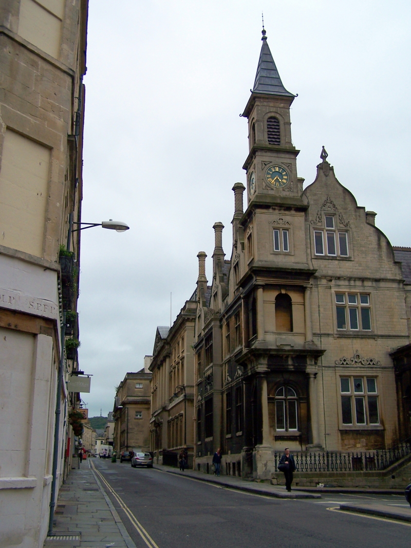
SAW CLOSE
656-1/40/1462 (East side)
Blue Coat House
05/08/75
GV II
Former school, now used as local government offices. 1859-1860 by G.P. Manners and J. Elkington Gill.
MATERIALS: Coursed and squared dressed stone, slate roofs with terracotta cresting to ridges.
EXTERIOR: Prominent freestanding building in eclectic Northern Renaissance style, with corner turret in five stages, main block, including hall, facing Upper Borough Walls, with two deep connected gabled wings. Two storeys, attic and basement. Entrance front to Saw Close of four bays: square turret to left, with engaged columns flanking arced openings to lowest two stages; third stage with two light mullioned window to each face, fourth stage with clock dial, fifth stage with slatted belfry-like ventilation opening, under leaded spire with concave sides. Tall curved gable elides with tower: six light mullion and transom windows to ground and first floors, four light within gable to attic, with strap work enrichment. Projecting entrance porch, more classical in style, with square columns to corners, arched openings to each face with imposts, shield with strap work surround over west side; entrance on north side with panelled door and fanlight, set in arch with deep keystone on short flight of steps with ornate cast iron railings. Two further bays to right with mullioned windows, smaller gable with oculus and finial to right, south-facing gabled roof with stack; sloping site permits insertion of a lower ground floor level at south-west corner. Long front to Upper Borough Walls has three large gables, each with large ornamental octagonal stack on square base over two-light casements, to ground and first floors, each side of large four-light with transom, under rich open strap work to the projecting centre bay. Plinth contains seven recessed lights. Centre band of middle bay has embellished strap work panel, including letters R and N (for Richard Nelson, founder of the school). Turret, to right, repeats front detail, but with blocked doorway on steps to ground floor. Return to Bridewell Lane has wide central canted bay under Flemish gable, with four-light casements, with transom to lower levels, to left. Rear has broad eaves stack to outer wing, and high gables with three-light and transom windows in simpler detail than remainder, gutter with crenellated leadwork detail runs across part of rear face.
INTERIOR: Mainly consist of large classrooms, rather plainer in character than the exterior. Central staircase with concrete treads.
HISTORY: A subscription for a charity school was opened by Robert Nelson, a prominent Low Church Anglican (d.1714) in 1711; work began on a school building, designed by William Killigrew, in 1722. This was demolished in 1859. A Roman tessellated pavement, discovered during building, works, is reputed to be preserved within this building. An assertive and highly characteristic High Victorian public building, challenging the dominant classicism of the city. The rebuilding, together with the westward expansion of the Royal Mineral Water Hospital, formed part of a major programme of civic improvements in this area of Bath. The school was sold in 1921, bought by the Bath Health Dept. in 1924, and opened as offices; an infant welfare centre was built to the rear in 1927. It is now used as local government offices.
SOURCES: R.E.M. Peach, 'Bath: Old and New' (1891), 139-42; Neil Jackson, 'Nineteenth Century Bath. Architects and Architecture' (1991), 201; Mike Chapman & Elizabeth Holland, 'The Development of Saw Close from the Middle Ages', Bath History VIII (2000), 71 ff.
Listing NGR: ST7490964859
External links are from the relevant listing authority and, where applicable, Wikidata. Wikidata IDs may be related buildings as well as this specific building. If you want to add or update a link, you will need to do so by editing the Wikidata entry.


Other nearby listed buildings
