Approximate Location Map
Large Map »
Latitude: 51.3814 / 51°22'53"N
Longitude: -2.3602 / 2°21'36"W
OS Eastings: 375025
OS Northings: 164772
OS Grid: ST750647
Mapcode National: GBR 0QH.B2Z
Mapcode Global: VH96M.1JLV
Plus Code: 9C3V9JJQ+HW
Entry Name: Nos. 1 and 2 the Roundhouse
Listing Date: 11 August 1972
Last Amended: 15 October 2010
Grade: II
Source: Historic England
Source ID: 1395173
English Heritage Legacy ID: 510587
ID on this website: 101395173
Location: Bath, Bath and North East Somerset, Somerset, BA1
County: Bath and North East Somerset
Parish: Non Civil Parish
Built-Up Area: Bath
Traditional County: Somerset
Lieutenancy Area (Ceremonial County): Somerset
Tagged with: Building
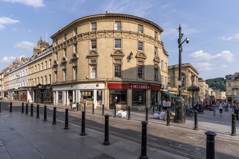
STALL STREET
656-1/41/1595 (East side)
Nos.1 AND 2 The Roundhouse
(Formerly Listed as:
CHEAP STREET No.21 & The Roundhouse)
11/08/72
GV II
Public house and shop. 1897. By Major Charles Davis, City Architect.
MATERIALS: Limestone ashlar, roof hidden from street. One composition with No.21 Cheap Street (qv).
PLAN: Single depth plan with rear top lit extension.
EXTERIOR: Three storeys plus attic storey, seven bays. Enriched Georgian Revival style exterior on prominent corner site between Cheap Street and Stall Street. Three bay front to No.1, 4 to No.2. Contemporary public house frontage to No.1 set below modillion cornice with consoles, and with panelled stone pilasters. modern shop front to No.2 out of seven window whole, sashes in moulded architraves, segmental pediments with carved tympanum to first floor windows, six/one-sashes, with rectangular light with margin glazing over. Windows above six/one-sashes. Deep frieze band with carved garlands and dentilled cornice above second floor windows. Modillion crowning cornice with ornamented bed mould. Ashlar stack with pots.
INTERIOR: Not inspected.
HISTORY: Originally the Abbey Wine Vaults. The church of St Mary de Stalle stood partly on this site until demolition in the C17. Part of the late Victorian municipal campaign of improvement in the city centre, executed in a characteristically assertive yet contextual idiom.
Listing NGR: ST7502564772
External links are from the relevant listing authority and, where applicable, Wikidata. Wikidata IDs may be related buildings as well as this specific building. If you want to add or update a link, you will need to do so by editing the Wikidata entry.


Other nearby listed buildings
