Approximate Location Map
Large Map »
Latitude: 51.3773 / 51°22'38"N
Longitude: -2.3637 / 2°21'49"W
OS Eastings: 374780
OS Northings: 164314
OS Grid: ST747643
Mapcode National: GBR 0QH.P6M
Mapcode Global: VH96L.ZN80
Plus Code: 9C3V9JGP+WG
Entry Name: 30 and 32, Wells Road
Listing Date: 5 August 1975
Last Amended: 15 October 2010
Grade: II
Source: Historic England
Source ID: 1395611
English Heritage Legacy ID: 511021
ID on this website: 101395611
Location: Beechen Cliff, Bath and North East Somerset, Somerset, BA2
County: Bath and North East Somerset
Parish: Non Civil Parish
Built-Up Area: Bath
Traditional County: Somerset
Lieutenancy Area (Ceremonial County): Somerset
Tagged with: Building
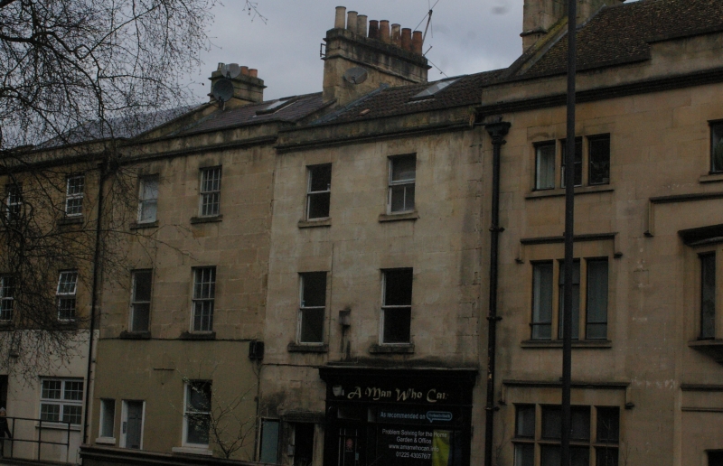
WELLS ROAD
656-1/40/1823 (North side)
Nos.30 and 32
(Formerly Listed as:
WELLS ROAD Nos.12-32 (Even))
05/08/75
GV II
Three houses in stepped row. c1820 with C20 additions.
MATERIALS: Limestone ashlar, double Roman tile, slate, or concrete tile roof.
EXTERIOR: Three storeys, with lower ground floors generated by drop in site from street front, each two windows, all sashes. No.30 has small access dormer to left, above plain sash, and reeded pilaster shop front including door with margin pane glazing. To left six-panel door, in projecting stone pilaster doorcase with incised panels and square corner blocks, hood slightly peaked, plus small plain light.
No.32 has plain and sixteen-pane above plain and twelve-pane, with small shopfront with original fascia and cornice, and part glazed door to left, with cast iron foot scraper. No.34 has rebuilt front, with twelve-pane sashes, and eight-pane shopfront and part-glazed door and very narrow light. Each has small plinth, dying to left, cornice, blocking course and parapet, coped party divisions, and deep ashlar stack to right. Rear not accessible.
INTERIORS: Not inspected.
HISTORY: These houses form part of a mixed development of the late C18 and early C19, and were formerly part of a much longer run of Georgian houses. A bomb destroyed Nos.36-40 Wells Road in 1942, and badly damaged the formerly listed No.34, which was extensively rebuilt thereafter. The remaining houses are survivals of the southern expansion of the city in the later Georgian period.
Listing NGR: ST7478064314
External links are from the relevant listing authority and, where applicable, Wikidata. Wikidata IDs may be related buildings as well as this specific building. If you want to add or update a link, you will need to do so by editing the Wikidata entry.


Other nearby listed buildings
