Approximate Location Map
Large Map »
Latitude: 51.3807 / 51°22'50"N
Longitude: -2.3638 / 2°21'49"W
OS Eastings: 374776
OS Northings: 164687
OS Grid: ST747646
Mapcode National: GBR 0QH.96J
Mapcode Global: VH96L.ZK6F
Plus Code: 9C3V9JJP+7F
Entry Name: Old Labour Exchange (Former Weights and Measures Office)
Listing Date: 24 April 2002
Last Amended: 15 October 2010
Grade: II
Source: Historic England
Source ID: 1395728
English Heritage Legacy ID: 511137
ID on this website: 101395728
Location: Kingsmead, Bath and North East Somerset, Somerset, BA1
County: Bath and North East Somerset
Parish: Non Civil Parish
Built-Up Area: Bath
Traditional County: Somerset
Lieutenancy Area (Ceremonial County): Somerset
Church of England Parish: Bath St Michael Without
Church of England Diocese: Bath and Wells
Tagged with: Architectural structure
MILK STREET
24/04/02
Old Labour
Exchange (Former
Weights and
Measures Office)
II
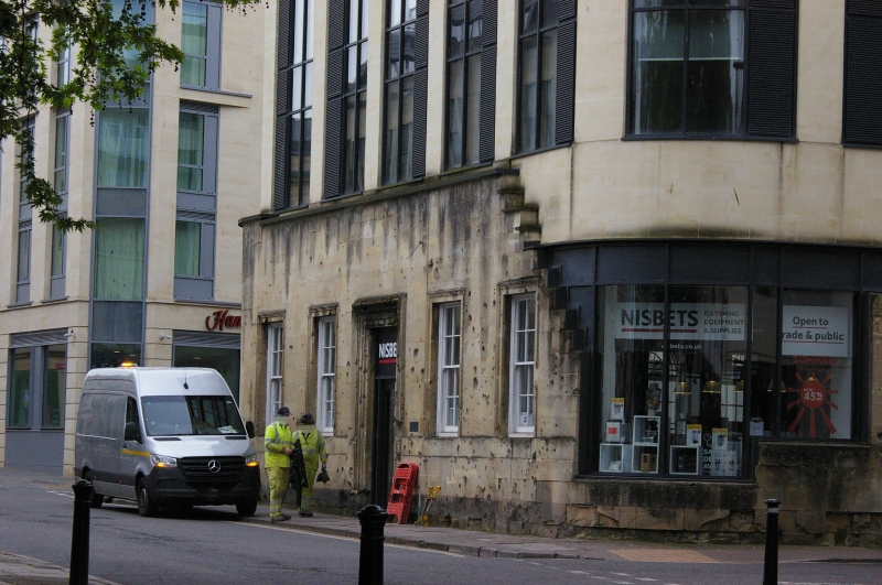
Former Labour Exchange, Milk Street. c1936, architect unknown. Bath stone facades, roof not seen. Now single storey. Five bay front to James Street West: central double doors within framed surround, six/six pane sash windows within aedicular surrounds. Rounded corners to sides, that at north-west badly damaged revealing inner structure. East return to Milk Street of eight bays, with framed doors at either end, inner four bays with arched windows, outer windows are six/six pane sashes. Right return is much damaged: three windows with metal mullions and transoms within aedicular surrounds, the central one showing extensive signs of fire damage above; later inserted window opening to first floor addition.
HISTORY: This building was badly damaged during one of the two 'Baedeker Raids' on Bath in March 1942, in which 417 persons were killed and thousands of buildings badly damaged or lost. It is remarkable for bearing the clear evidence of shrapnel damage from high explosive bombs which were dropped just south of Kingsmead Square. The building is listed on account of the façade: the structure behind is of much lesser significance.
SOURCES: 'Bath under Bombardment' (1942); Martin Wainwright, 'Blitz on Bath' (3rd ed. 1992); Niall Rothnie, 'The Baedeker Blitz' (1992).
Listing NGR: ST7477664687
External links are from the relevant listing authority and, where applicable, Wikidata. Wikidata IDs may be related buildings as well as this specific building. If you want to add or update a link, you will need to do so by editing the Wikidata entry.


Other nearby listed buildings
