Approximate Location Map
Large Map »
Latitude: 51.3833 / 51°22'59"N
Longitude: -2.3678 / 2°22'4"W
OS Eastings: 374497
OS Northings: 164977
OS Grid: ST744649
Mapcode National: GBR 0QH.85M
Mapcode Global: VH96L.XH2F
Plus Code: 9C3V9JMJ+8V
Entry Name: 10, Monmouth Place
Listing Date: 5 August 1975
Last Amended: 15 October 2010
Grade: II
Source: Historic England
Source ID: 1396043
English Heritage Legacy ID: 511459
ID on this website: 101396043
Location: Kingsmead, Bath and North East Somerset, Somerset, BA1
County: Bath and North East Somerset
Parish: Non Civil Parish
Built-Up Area: Bath
Traditional County: Somerset
Lieutenancy Area (Ceremonial County): Somerset
Church of England Parish: Bath St Michael Without
Church of England Diocese: Bath and Wells
Tagged with: Building
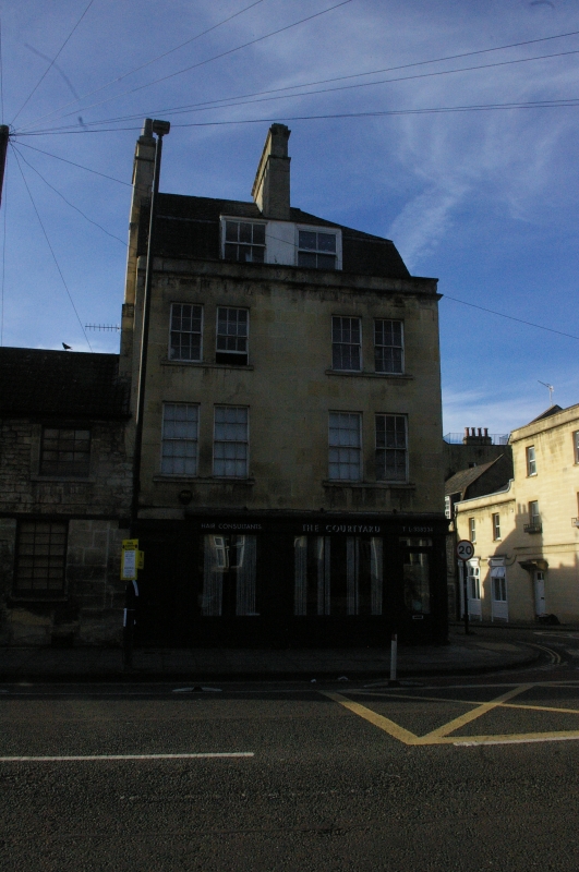
MONMOUTH PLACE
No.10 (Formerly
Listed as: UPPER
BRISTOL ROAD
No.10 Monmouth Place)
05/08/75
GV II
Shop with accommodation over. Late C18 early C19.
MATERIALS: Limestone ashlar, Welsh slate roof.
PLAN: Three storeys and attic, two + two windows to Monmouth Place.
EXTERIOR: Altered early C19 shopfront to ground floor, two separate windows two:three lights divided by stone pilaster and with stone stallrisers. Timber mullions and fascia, part glazed shop door to right, six-panel house door to left. Floors above have paired six/six-sashes with stone mullion between. Small cornice, parapet, mansard roof, paired dormer with six/six-sashes, two ashlar stacks with weathering. Little Stanhope Street elevation has additional three-light shop window, and single blind window on each floor above. Additional two storey bay to right, with one six/six-sash to each floor and lean-to roof. Rear elevation not seen.
INTERIOR: Inspected 1983, original shutters throughout and original fireplaces and grates, one of them very low, on third floor.
HISTORY: This building shows considerable evidence of reconstruction and repair following bomb damage in April 1942.
SOURCES: Finch G: Shopfront Record, Bath City Council: 1992.
Listing NGR: ST7449764977
External links are from the relevant listing authority and, where applicable, Wikidata. Wikidata IDs may be related buildings as well as this specific building. If you want to add or update a link, you will need to do so by editing the Wikidata entry.


Other nearby listed buildings
