Approximate Location Map
Large Map »
Latitude: 51.3829 / 51°22'58"N
Longitude: -2.3591 / 2°21'32"W
OS Eastings: 375106
OS Northings: 164931
OS Grid: ST751649
Mapcode National: GBR 0QH.BC7
Mapcode Global: VH96M.2H6R
Plus Code: 9C3V9JMR+59
Entry Name: 15 and 16, Northgate Street
Listing Date: 5 August 1975
Last Amended: 15 October 2010
Grade: II
Source: Historic England
Source ID: 1396190
English Heritage Legacy ID: 511599
ID on this website: 101396190
Location: Bath, Bath and North East Somerset, Somerset, BA1
County: Bath and North East Somerset
Parish: Non Civil Parish
Built-Up Area: Bath
Traditional County: Somerset
Lieutenancy Area (Ceremonial County): Somerset
Church of England Parish: Bath St Michael Without
Church of England Diocese: Bath and Wells
Tagged with: Building
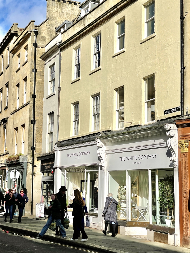
NORTHGATE STREET
(East side)
Nos.15 AND 16
(Formerly Listed as:
NORTHGATE STREET
Nos.14-16 (Consec))
05/08/75
GV II
Houses, now shops with accommodation over. Late C18/early C19 with C20 alterations.
MATERIALS: Limestone ashlar, now painted, with Welsh slate roofs.
PLAN: Shallow double depth houses.
EXTERIOR: Three storeys with attics, two windows each, but with different sill levels. They appear to have been built together, but some suspicion of vertical joint between them. Late C19/early C20 shopfronts, both double fronted, both with pilasters. No.16 with consoles, better and earlier one. Plain sash windows in reveals, No.16 has slightly lower sills on first floor, and slightly higher ones on second floor. All late C19 plate glass plain sashes. Second floor of No.15, which has late C18 type six/six-sashes. Moulded cornice and parapet, mansard roof with two gabled dormers each, with six/six-sashes, stone stacks with pots.
INTERIORS: Only ground floor inspected, nothing of special interest.
HISTORY: These houses are built immediately within the line of the City Wall, and looking onto the site of the Northgate, which was demolished in 1755. They also stand on a part of the site of St Mary `intra-muros' Church which was demolished in the C17.
SOURCES: Finch G: Shopfront Record, Bath City Council: 1992-.
Listing NGR: ST7510664931
External links are from the relevant listing authority and, where applicable, Wikidata. Wikidata IDs may be related buildings as well as this specific building. If you want to add or update a link, you will need to do so by editing the Wikidata entry.


Other nearby listed buildings
