Approximate Location Map
Large Map »
Latitude: 51.3834 / 51°23'0"N
Longitude: -2.3603 / 2°21'37"W
OS Eastings: 375022
OS Northings: 164985
OS Grid: ST750649
Mapcode National: GBR 0QH.B29
Mapcode Global: VH96M.1HKC
Plus Code: 9C3V9JMQ+8V
Entry Name: 13, Green Street
Listing Date: 5 August 1975
Last Amended: 15 October 2010
Grade: II
Source: Historic England
Source ID: 1396310
English Heritage Legacy ID: 511714
ID on this website: 101396310
Location: Bath, Bath and North East Somerset, Somerset, BA1
County: Bath and North East Somerset
Parish: Non Civil Parish
Built-Up Area: Bath
Traditional County: Somerset
Lieutenancy Area (Ceremonial County): Somerset
Church of England Parish: Bath St Michael Without
Church of England Diocese: Bath and Wells
Tagged with: Building
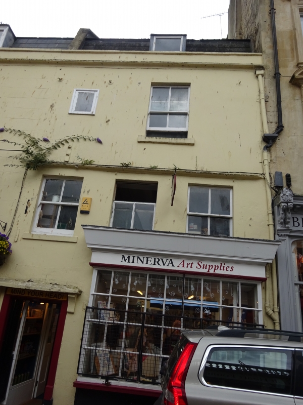
GREEN STREET
(South side)
No.13 (Formerly Listed as: GREEN
STREET (South side) Nos 10 & 11, No.12
(The Old Green Tree Public House). No.
13)
05/08/75
GV II
Terrace house, now shop with accommodation over. Early C18, altered and heightened early C19, with C20 alterations.
MATERIALS: Limestone ashlar, now painted.
PLAN: Narrow double depth plan.
EXTERIOR: Three storeys and attic with stringcourse at second floor level, and to parapet. Good early C19 shopfront of nine x four panes (narrow side panes), frieze and deep fascia, apparently early C18 doorway to left, brackets to cornice hood over door. First floor has three recessed plate glass sashes, second floor has one similar plus small square window. Mansard roof with single flat-topped dormer.
INTERIOR: Of shop altered, otherwise not inspected.
HISTORY: It is said that Bath Oliver biscuits were first baked and sold on this premises. Green Street was laid out in 1716, and the surviving two lower floors suggest this may be an original build. Fourteen houses were recorded by John Wood in his 'Essay towards a Description of Bath', 1749.
SOURCES: (Finch G: Shopfront Record, Bath City Council: 1992-)
Listing NGR: ST7502264985
External links are from the relevant listing authority and, where applicable, Wikidata. Wikidata IDs may be related buildings as well as this specific building. If you want to add or update a link, you will need to do so by editing the Wikidata entry.


Other nearby listed buildings
