Approximate Location Map
Large Map »
Latitude: 58.5753 / 58°34'31"N
Longitude: -4.7679 / 4°46'4"W
OS Eastings: 239144
OS Northings: 968570
OS Grid: NC391685
Mapcode National: GBR G6L2.4RH
Mapcode Global: WH26J.QQRG
Plus Code: 9CCQH6GJ+4R
Entry Name: Balnakeil Mill
Listing Name: Balnakeil Former Corn Mill
Listing Date: 7 March 1984
Category: B
Source: Historic Scotland
Source ID: 330828
Historic Scotland Designation Reference: LB518
Building Class: Cultural
ID on this website: 200330828
Location: Durness
County: Highland
Electoral Ward: North, West and Central Sutherland
Parish: Durness
Traditional County: Sutherland
Tagged with: Watermill
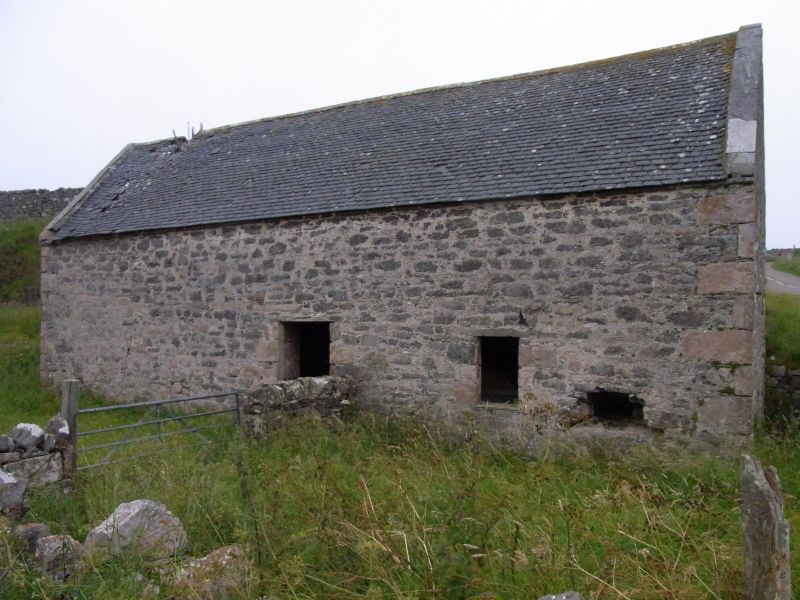
Early 19th century. 2-storey, rectangular-plan, gabled former water-pwered grain mill situated on sloping site with man-made embankment to 1st-floor entrance at rear. Roughly coursed rubble with sandstone dressings. Long and short quoins and window margins. Principle elevation to NE with central door and window to right. Entrance doorway with piended roof breaking eaves to rear (SW) elevation. Irregular fenestration to gables; opening for water wheel shaft at lower ground floor to SW gable; small opening above right and further central opening at 1st floor. Ashlar-coped skews. Graded grey Scottish slate. Flue aperture in ridge to N for kiln.
INTERIOR: significant remains of grinding machinery and gear cupboard situated at ground floor to S end of the mill with mill wheels, set in timber frame, located in floor directly above. Circular, stone-lined kiln with sloping sides to Nothern end. Gear cupboard with wooden bridge piece, grain shoot and surrounding wooden partitions in situ. Some spur gear machinery survives including wooden mill-stone drive wheel, belt-drive wheels and iron cogs. Stone flags to floor. Roof timbers and beams reinforced with additional timbers along E side.
MILL LADE: concrete and stone lined lade (now partially ruinous) runs from Loch Croispol to S with narrower section running along E side of mill towards Balnakeil House.
A-Group with Balnakeil House (see separate listing). Balnakeil mill is a rare surviving example of an early 19th century water powered threshing mill with kiln retaining much of its former context as well as a considerable amount of interior fabric. The building is located to the immediate S of Balnakeil House and, along with the remains of the Durness Old Parish Church and Burial Ground (see separate listing), contributes greatly to the wider landscape setting of the group as a whole.
The survival of its associated lade and its relation to the nearby listed Balnakeil House provide further interest. The corn mill was powered by water from Loch Croispol which is situated to the S of the mill. A sluice at the northern tip of the loch controlled the water from the loch into the mill lade. The lade runs along the E of the mill and a further sluice to the S fed water into the wheelpit. The high breast-shot water wheel was attached to the S elevation. The water from the wheel pit ran into an underground tail race to meet the stream which runs to the W of the mill. The lade continues from the mill towards Balnakeil House where the water drove a second water wheel. This wheel powered a threshing mill rope drive, the remains of which are situated about 100m E of the wheel. The mill was last used at sometime between 1911 and 1914, at which time it was principaly used for grinding meal.
Balnakeil sits on limestone rock, giving rise to highly fertile soil, unusual in the NW highlands. A mill on the site is shown on Timothy Pont's map of 1590-1600. However, the present building was constructed c.1830 following the acquisition of the Reay Estate from Lord MacKay by the Duke of Sutherland.
Balnakeil House (see separate listing) is a mid 18th century country house (listed at category A) built on the site of the summer residence of the Bishops of Sutherland and Caithness and formerly used as an occasional residence of the Lords of Reay.
This list description was updated and the category changed from C(S) to B in 2007.
External links are from the relevant listing authority and, where applicable, Wikidata. Wikidata IDs may be related buildings as well as this specific building. If you want to add or update a link, you will need to do so by editing the Wikidata entry.


Other nearby listed buildings
